View over fields from the roof of Brooke Court
Introduction
The photograph on this page of View over fields from the roof of Brooke Court by Alan Walker as part of the Geograph project.
The Geograph project started in 2005 with the aim of publishing, organising and preserving representative images for every square kilometre of Great Britain, Ireland and the Isle of Man.

There are currently over 7.5m images from over 14,400 individuals and you can help contribute to the project by visiting https://www.geograph.org.uk
View over fields from the roof of Brooke Court
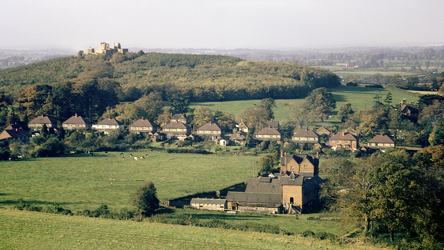
Image: © Alan Walker Taken: Unknown
This is the view over fields from the roof of Brooke Court (which was adjacent to Image) as it existed in the autumn of 1969. The row of houses in the middle distance are on Castle Bank (A518) which, to the right, becomes Newport Road. A short distance to the left (south-west) the A518 passes under the M6 motorway. In the distance, on the hill, are the ruins of Stafford Castle. Since this photograph was taken all the fields in the foreground have been built over with housing and the farm house demolished. To see almost the same view, but early on a foggy morning, click here: http://www.geograph.org.uk/photo/2244917 . See this photograph by Simon Huguet http://www.geograph.org.uk/photo/1136212 , which shows the view (2009) back toward the viewpoint of this photograph and in which can be seen the Milton Court. Milton Court and Brooke Court were on the same site, although Brooke Court has since been demolished. - - - Note: The Date Taken is the processing date printed on the slide and therefore the photograph could have been taken several weeks earlier.
Images are licensed for reuse under creativecommons.org/licenses/by-sa/2.0
Image Location
Latitude
52.794761
Longitude
-2.141141