IMAGES TAKEN NEAR TO
Waterside Place, Tenby Drive, STAFFORD, ST16 3ZD
Introduction
This page details the photographs taken nearby to Waterside Place, Tenby Drive, ST16 3ZD by members of the Geograph project.
The Geograph project started in 2005 with the aim of publishing, organising and preserving representative images for every square kilometre of Great Britain, Ireland and the Isle of Man.

There are currently over 7.5m images from over14,400 individuals and you can help contribute to the project by visiting https://www.geograph.org.uk
Image Map (Loading...)


Getting Data...Please wait
Leaflet Map data © OpenStreetMap
Images are licensed for reuse under creativecommons.org/licenses/by-sa/2.0
Notes
- Clicking on the map will re-center to the selected point.
- The higher the marker number, the further away the image location is from the centre of the postcode.
Image Listing (11 Images Found)
Images are licensed for reuse under creativecommons.org/licenses/by-sa/2.0
Image
Details
Distance
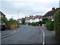
1

B5066 Sandon Road Stafford
Looking out of town along the B5066 with the junction of Fontill Road just on the right. The houses are all built in the 1930's.
Image: © Stephen Pearce
Taken: 22 Sep 2006
0.05 miles

3
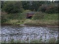
Railway overbridge near Astonfields Balancing Lakes
View of railway overbridge east of Stafford Common Railway station. This line closed to Passengers on 4th December 1939. The line survived for freight and for special servicemens trains until final closure to all regular traffic on 5th March 1951, the last train over the line being an SLS special in March 1957. The track east of this point was lifted in 1959 but the remainder was retained for use by engineers in connection with electrification work on the West Coast Main Line. This stub was finally taken out of use in December 1975.
Image: © Tim Marshall
Taken: 30 Sep 2008
0.10 miles
4
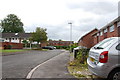
Fairfield Court, off the B5066, Stafford
Image: © Mick Malpass
Taken: 17 Jul 2011
0.13 miles
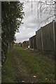
7
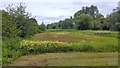
Astonfields Balancing Lakes, Stafford
A view of the South lake, from the spillway. The site is now treated as a nature reserve, with footpaths running along the perimeter.
Image: © Oliver Mills
Taken: 14 Jul 2020
0.15 miles
8
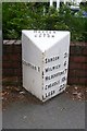
Old Milepost by the B5066, Sandon Road, Stafford
Cast iron milepost by the B5066, in parish of Hopton and Coton (Stafford District), Stafford, North East of town centre, in path in front of low brick wall, on South East side of road. Lathe iron casting, erected by the County Council in the 19th/20th century.
Inscription reads:-
:STAFFORD 1 : : HOPTON / AND / COTON : : SANDON 3½ / MILWICH 6 / HILDERSTONE 7 / CHEADLE 15½ / LEEK 22½ :
Maker:-
: Chas. Lathe, Tipton. :
Milestone Society National ID: ST_STLK01
Image: © J Higgins
Taken: 1 Jan 2000
0.15 miles
9
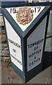
Old Boundary Marker by the B5066, Sandon Road, Stafford parish
Parish Boundary Marker by the B5066, in parish of Stafford (Stafford District), Sandon Road, 200m West of junction with A513, Northwest side of road.
Inscription reads:-
: BOROUGH / OF / STAFFORD : : 19 / {coat of arms} 17 : : TOWNSHIP / OF / HOPTON / & / COPTON :
Surveyed
Milestone Society National ID: ST_SFHC02pb
Image: © Milestone Society
Taken: Unknown
0.15 miles