IMAGES TAKEN NEAR TO
Homestead Court, STAFFORD, ST16 3HU
Introduction
This page details the photographs taken nearby to Homestead Court, ST16 3HU by members of the Geograph project.
The Geograph project started in 2005 with the aim of publishing, organising and preserving representative images for every square kilometre of Great Britain, Ireland and the Isle of Man.

There are currently over 7.5m images from over14,400 individuals and you can help contribute to the project by visiting https://www.geograph.org.uk
Image Map
Images are licensed for reuse under creativecommons.org/licenses/by-sa/2.0
Notes
- Clicking on the map will re-center to the selected point.
- The higher the marker number, the further away the image location is from the centre of the postcode.
Image Listing (8 Images Found)
Images are licensed for reuse under creativecommons.org/licenses/by-sa/2.0
Image
Details
Distance
1
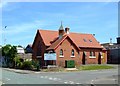
St Alban's Church, Stafford
Founded as a Mission Church for a community of salt workers who lived this side of Stafford Common this little church is now closed. Initially a speech and drama studio it is now the headquarters of the County Federation of the Women's Institute.
Image: © Simon Huguet
Taken: 26 Jul 2008
0.10 miles
2
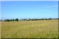
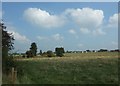
Stafford Common
Looking across the grazing land of Stafford Common towards Parkside. The prominent white building is Sir Graham Balfour School.
Image: © Simon Huguet
Taken: 26 Jul 2008
0.12 miles
3
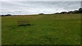
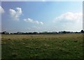
Stafford Common
Open-access land at the North end of Stafford.
Image: © Oliver Mills
Taken: 14 Jul 2020
0.12 miles
4
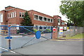
Stafford Recycling Centre
The place for waste disposal run by the county council. It is very clean relatively.
Image: © Bill Boaden
Taken: 1 Apr 2011
0.18 miles
6
Stafford Common
Looking across Stafford Common towards the Astonfields Industrial Estate.
Current development proposals for Stafford include potential land for houses identified as '149 acres off Stone Road'. Could this be it?
Image: © Simon Huguet
Taken: 18 Sep 2008
0.19 miles
7
Evo Stik Factory, Common Road, Stafford
Image: © Mick Malpass
Taken: 17 Jul 2011
0.23 miles
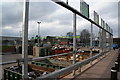
8

Site of Stafford Common Railway Station
This section of railway has been converted to a footpath and cycle route, connecting the A513 road to the centre of Stafford. The platforms of the station are visible on the right.
Image: © Oliver Mills
Taken: 14 Jul 2020
0.24 miles