IMAGES TAKEN NEAR TO
Tudor Rise, STAFFORD, ST16 1LH
Introduction
This page details the photographs taken nearby to Tudor Rise, ST16 1LH by members of the Geograph project.
The Geograph project started in 2005 with the aim of publishing, organising and preserving representative images for every square kilometre of Great Britain, Ireland and the Isle of Man.

There are currently over 7.5m images from over14,400 individuals and you can help contribute to the project by visiting https://www.geograph.org.uk
Image Map (Loading...)


Getting Data...Please wait
Leaflet Map data © OpenStreetMap
Images are licensed for reuse under creativecommons.org/licenses/by-sa/2.0
Notes
- Clicking on the map will re-center to the selected point.
- The higher the marker number, the further away the image location is from the centre of the postcode.
Image Listing (22 Images Found)
Images are licensed for reuse under creativecommons.org/licenses/by-sa/2.0
Image
Details
Distance
1

Redhill, Stafford
Three semi-detached houses line the north side of Redhill at its junction with First Avenue in the Trinity Fields area of Stafford.
Image: © Stephen McKay
Taken: 24 Sep 2020
0.05 miles
3
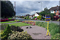
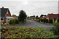
Crab Lane, Stafford
Seen from the junction with First Avenue in the Trinity Fields district of Stafford. There are some neat gardens in this area.
Image: © Stephen McKay
Taken: 24 Sep 2020
0.10 miles
4
Crab Lane, Stafford
Redhill Gorse leads off to the left; in the foreground is a semi-detached bungalow with semi-detached houses further along.
Image: © Stephen McKay
Taken: 24 Sep 2020
0.11 miles
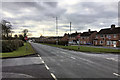
6
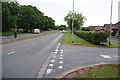
Stone Road, Stafford, looking south
A section of the Stone Road (A34) in Stafford. The Redhill roundabout is behind the photographer. The road become a single carriageway just beyond the curve to the right. The single carriageway section can just be made out in the background beyond the northbound carriageway. The start of Crab Lane is visible on the right leaving the northbound carriageway,
Image: © Rod Grealish
Taken: 17 Oct 2023
0.14 miles
8
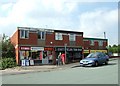
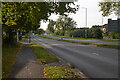
The A34 heading into Stafford
It passes through some fairly nondescript residential areas before reaching fringe businesses.
Image: © Bill Boaden
Taken: 20 Sep 2013
0.17 miles
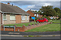
9
Redhill Gorse
A residential road right on the northern edge of Stafford.
Image: © Bill Boaden
Taken: 20 Sep 2013
0.17 miles
10
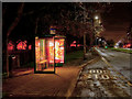
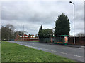
Bus Shelter on Stone Road
The A34 heading into Stafford.
Image: © David Dixon
Taken: 3 Feb 2019
0.18 miles