IMAGES TAKEN NEAR TO
STONE, ST15 9FF
Introduction
This page details the photographs taken nearby to ST15 9FF by members of the Geograph project.
The Geograph project started in 2005 with the aim of publishing, organising and preserving representative images for every square kilometre of Great Britain, Ireland and the Isle of Man.

There are currently over 7.5m images from over14,400 individuals and you can help contribute to the project by visiting https://www.geograph.org.uk
Image Map
Images are licensed for reuse under creativecommons.org/licenses/by-sa/2.0
Notes
- Clicking on the map will re-center to the selected point.
- The higher the marker number, the further away the image location is from the centre of the postcode.
Image Listing (6 Images Found)
Images are licensed for reuse under creativecommons.org/licenses/by-sa/2.0
Image
Details
Distance
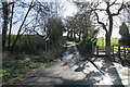
1
Pirehill Lane, Stone
This is where the tarmac ends
Image: © Jack Barber
Taken: 23 Feb 2007
0.07 miles
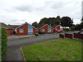
2
Pirehill Lane
This is the point at which the housing development ends. The 30 mph speed limit ends here too, but in view of the width of the road, I don't think drivers will be able to take advantage.
Image: © Bill Boaden
Taken: 24 Feb 2022
0.09 miles
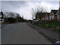
3
Pirehill Lane, Stone
Stone Rural BOAT 63 becomes a tarmac road and the suburbs of Stone begin here.
Image: © Derek Harper
Taken: 7 Sep 2012
0.10 miles
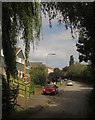
4
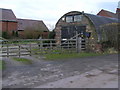
Oak Farm, Pirehill Lane, Stone
About to under a barn conversion, OK if you have a 4X4.
Image: © Jack Barber
Taken: 23 Feb 2007
0.11 miles
5
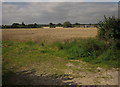
Wheat by Pirehill Lane
With houses on Coombe Park Road at the edge of the Stone suburbs across the fields.
Image: © Derek Harper
Taken: 7 Sep 2012
0.24 miles