IMAGES TAKEN NEAR TO
Cherry Orchard, STONE, ST15 8QS
Introduction
This page details the photographs taken nearby to Cherry Orchard, ST15 8QS by members of the Geograph project.
The Geograph project started in 2005 with the aim of publishing, organising and preserving representative images for every square kilometre of Great Britain, Ireland and the Isle of Man.

There are currently over 7.5m images from over14,400 individuals and you can help contribute to the project by visiting https://www.geograph.org.uk
Image Map
Images are licensed for reuse under creativecommons.org/licenses/by-sa/2.0
Notes
- Clicking on the map will re-center to the selected point.
- The higher the marker number, the further away the image location is from the centre of the postcode.
Image Listing (5 Images Found)
Images are licensed for reuse under creativecommons.org/licenses/by-sa/2.0
Image
Details
Distance
1
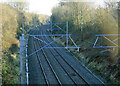
2008 : South east from Pringle Lane railway bridge
The former L.M.S. line from Stoke on Trent heading toward Stafford having passed through Stone.
Image: © Maurice Pullin
Taken: 26 Dec 2008
0.04 miles
2
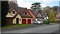
Parkhouse Drive
A quiet cul-de-sac on the outskirts of Stone.
Image: © Peter Mackenzie
Taken: 26 Apr 2017
0.11 miles
3
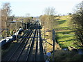
2008 : From the railway bridge on Pingle Lane
Looking north west toward Stone.
Image: © Maurice Pullin
Taken: 26 Dec 2008
0.12 miles
4

Lane behind houses from Andre Mills Bridge
Image: © David Martin
Taken: 25 Jul 2015
0.18 miles
5
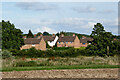
Farmland and housing in Stone, Staffordshire
A telephoto assisted image from about five hundred metres of houses in cul-de-sacs off Priory Road, near Gower Road.
Looking south-east from Westbridge Park. The Trent and Mersey Canal crosses the scene by trees in front of the housing.
Image: © Roger Kidd
Taken: 29 Jul 2015
0.24 miles