IMAGES TAKEN NEAR TO
Moore Close, STONE, ST15 8FZ
Introduction
This page details the photographs taken nearby to Moore Close, ST15 8FZ by members of the Geograph project.
The Geograph project started in 2005 with the aim of publishing, organising and preserving representative images for every square kilometre of Great Britain, Ireland and the Isle of Man.

There are currently over 7.5m images from over14,400 individuals and you can help contribute to the project by visiting https://www.geograph.org.uk
Image Map (Loading...)


Getting Data...Please wait
Leaflet Map data © OpenStreetMap
Images are licensed for reuse under creativecommons.org/licenses/by-sa/2.0
Notes
- Clicking on the map will re-center to the selected point.
- The higher the marker number, the further away the image location is from the centre of the postcode.
Image Listing (90 Images Found)
Images are licensed for reuse under creativecommons.org/licenses/by-sa/2.0
Image
Details
Distance
1
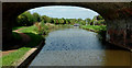
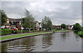
Trent and Mersey Canal approaching Stone, Staffordshire
Looking north-west through the arch of Brassworks Bridge, No 91.
Image: © Roger D Kidd
Taken: 2 Sep 2014
0.02 miles
3
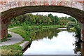
Trent and Mersey Canal approaching Stone in Staffordshire
At Brassworks Bridge, No 91, looking north-west towards Stone town centre and Stoke-on-Trent.
Image: © Roger Kidd
Taken: 10 Sep 2019
0.02 miles
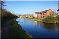
4
Trent and Mersey Canal approaching Stone, Staffordshire
Housing on the right is in Simeon Way.
Image: © Roger D Kidd
Taken: 2 Sep 2014
0.02 miles
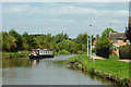
5
Trent and Mersey Canal near Little Stoke, Staffordshire
The housing is recent.
Image: © Roger D Kidd
Taken: 3 Sep 2011
0.03 miles
6
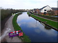
Laying a new towpath surface on the Trent and Mersey Canal
Forcing a rather tedious detour to the next bridge
Image: © Tim Heaton
Taken: 27 Mar 2017
0.04 miles
7
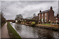
Brassworks Farm and Brassworks Bridge No.91, Trent & Mersey Canal, Stone
Brassworks Farmhouse facing The Trent and Mersey Canal in Stone, built 1794. George Vernon made Copper and brass wire here in the early 1800's. Grade II Listed building.
Image: © Brian Deegan
Taken: 20 Feb 2021
0.05 miles
8
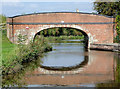
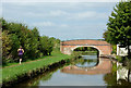
Brassworks Bridge south-east of Stone, Staffordshire
There was a brass foundry nearby which is recalled by the name of this bridge and the nearby 18th century farm house. This bridge (No 91 across the Trent and Mersey Canal) would have been an accommodation bridge allowing farm access to riverside pastures before the land to the right was developed for housing. Maybe livestock can still be brought through the housing in transporters - the bridge is still in use.
Image: © Roger D Kidd
Taken: 2 Sep 2014
0.05 miles
9
Brassworks Bridge south-east of Stone, Staffordshire
There was a brass foundry nearby which is recalled by the name of this bridge and the nearby 18th century farm house. This bridge (No 91 across the Trent and Mersey Canal) would have been an accommodation bridge allowing farm access to riverside pastures before the land to the right was developed for housing. Maybe livestock can still be brought through the housing in transporters - the bridge is still in use.
Image: © Roger D Kidd
Taken: 2 Sep 2014
0.05 miles
10
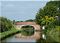
Brassworks Bridge south-east of Stone, Staffordshire
There was a brass foundry nearby which is recalled by the name of this bridge and the nearby 18th century farm house. This bridge (No 91 across the Trent and Mersey Canal) would have been an accommodation bridge allowing farm access to riverside pastures before the land to the right was developed for housing. Maybe livestock can still be brought through the housing in transporters - the bridge is still in use.
St Michael's Church tower can be seen on the skyline.
Image: © Roger D Kidd
Taken: 2 Sep 2014
0.05 miles