IMAGES TAKEN NEAR TO
Newman Close, STONE, ST15 8FR
Introduction
This page details the photographs taken nearby to Newman Close, ST15 8FR by members of the Geograph project.
The Geograph project started in 2005 with the aim of publishing, organising and preserving representative images for every square kilometre of Great Britain, Ireland and the Isle of Man.

There are currently over 7.5m images from over14,400 individuals and you can help contribute to the project by visiting https://www.geograph.org.uk
Image Map
Images are licensed for reuse under creativecommons.org/licenses/by-sa/2.0
Notes
- Clicking on the map will re-center to the selected point.
- The higher the marker number, the further away the image location is from the centre of the postcode.
Image Listing (2 Images Found)
Images are licensed for reuse under creativecommons.org/licenses/by-sa/2.0
Image
Details
Distance
1
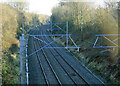
2008 : South east from Pringle Lane railway bridge
The former L.M.S. line from Stoke on Trent heading toward Stafford having passed through Stone.
Image: © Maurice Pullin
Taken: 26 Dec 2008
0.20 miles
2
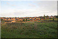
town meets country
Aston Lodge Park at Little Stoke on SE edge of Stone. Built over a period of 25 years; the houses shown being ca. 10 years old.
Image: © David Emley
Taken: 5 Nov 2006
0.22 miles