IMAGES TAKEN NEAR TO
Station Road, STONE, ST15 8EN
Introduction
This page details the photographs taken nearby to Station Road, ST15 8EN by members of the Geograph project.
The Geograph project started in 2005 with the aim of publishing, organising and preserving representative images for every square kilometre of Great Britain, Ireland and the Isle of Man.

There are currently over 7.5m images from over14,400 individuals and you can help contribute to the project by visiting https://www.geograph.org.uk
Image Map (Loading...)


Getting Data...Please wait
Leaflet Map data © OpenStreetMap
Images are licensed for reuse under creativecommons.org/licenses/by-sa/2.0
Notes
- Clicking on the map will re-center to the selected point.
- The higher the marker number, the further away the image location is from the centre of the postcode.
Image Listing (314 Images Found)
Images are licensed for reuse under creativecommons.org/licenses/by-sa/2.0
Image
Details
Distance
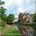
1
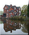
St Dominic's Preparatory School, Stone, Staffordshire
This view of the school is seen from the towpath of the Trent and Mersey Canal, by Lock No 29.
Image: © Roger D Kidd
Taken: 12 Oct 2007
0.02 miles
3

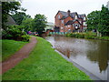
Station Road, Stone
This is the B5027, but it only carries the status of a B road as far as the level crossing in the distance. On the right is Northesk Street.
Image: © Derek Harper
Taken: 7 Sep 2012
0.03 miles
4
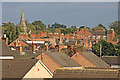
Across the rooftops in Stone, Staffordshire
This is a telephoto assisted image, looking east-south-east across Stonefield from the railway footbridge in evening autumn sunlight. On the left is the spire of St John's Church.
Image: © Roger Kidd
Taken: 16 Sep 2019
0.04 miles
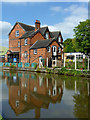
5
St Dominic's Preparatory School in Stone, Staffordshire
The school is seen here across the Trent and Mersey Canal near Newcastle Road Lock (Lime Kiln Lock) No 30.
Very considerable expansion and building has been carried out since this image was taken in 2014.
Image: © Roger Kidd
Taken: 10 Sep 2014
0.04 miles
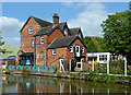
6
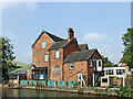
Canal and St Dominic's in Stone, Staffordshire
This shows the Trent and Mersey Canal, looking north from Newcastle Road Lock, No 29. The red-brick building is part of St Dominic's Priory School. Sustrans Route No 5 for cyclists uses the towpath here. https://www.sustrans.org.uk/find-a-route-on-the-national-cycle-network/route-5/
Image: © Roger Kidd
Taken: 31 May 2011
0.04 miles
7
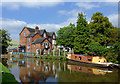
Canal, school and narrowboat at Stone, Staffordshire
Trent and Mersey Canal. The image, taken from to top of Newcastle Road Lock (No 29) shows part of St Dominic's Preparatory School, and a narrowboat called "Cutter".
Image: © Roger D Kidd
Taken: 2 Sep 2014
0.04 miles
8
St Dominic's Preparatory School in Stone, Staffordshire
The school is seen here across the Trent and Mersey Canal near Newcastle Road Lock.
Image: © Roger D Kidd
Taken: 2 Sep 2014
0.04 miles
9
St Dominic's Preparatory School in Stone, Staffordshire
The school is seen here across the Trent and Mersey Canal near Newcastle Road Lock.
Image: © Roger D Kidd
Taken: 2 Sep 2014
0.04 miles
10
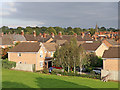
Housing in Stone, Staffordshire
This estate is in the Stonefield area of Stone, seen by looking east from the railway footbridge in evening autumn sunlight. The foreground houses are in Trinity Drive.
Image: © Roger Kidd
Taken: 16 Sep 2019
0.04 miles