IMAGES TAKEN NEAR TO
Church Street, STONE, ST15 8BD
Introduction
This page details the photographs taken nearby to Church Street, ST15 8BD by members of the Geograph project.
The Geograph project started in 2005 with the aim of publishing, organising and preserving representative images for every square kilometre of Great Britain, Ireland and the Isle of Man.

There are currently over 7.5m images from over14,400 individuals and you can help contribute to the project by visiting https://www.geograph.org.uk
Image Map
Images are licensed for reuse under creativecommons.org/licenses/by-sa/2.0
Notes
- Clicking on the map will re-center to the selected point.
- The higher the marker number, the further away the image location is from the centre of the postcode.
Image Listing (283 Images Found)
Images are licensed for reuse under creativecommons.org/licenses/by-sa/2.0
Image
Details
Distance
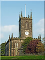
2
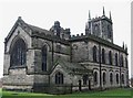
St Michael's Church, Stone
Built in 1753, on the site of the former St Ulfred's church, which collapsed in 1749.
Image: © Eirian Evans
Taken: 5 Aug 2008
0.02 miles
3
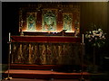
High altar, St Michael & St Wulfad's Church
An "inside" look on a dark November afternoon
Image: © Ian Cardinal
Taken: 8 Nov 2006
0.03 miles
4
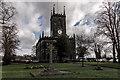
St Michael & St Wulfad Church, Stone
St. Michael's was built in 1758 on the site of the twelfth century Priory Church of St. Mary and St. Wulfad. The present church was designed by William Robinson of Greenwich and the main building work was undertaken by Charles Cope Trubshaw of Great Haywood.
In the churchyard can be found the mausoleum of the Earl of St. Vincent, Nelson's Admiral, and the tombs of the Crompton family.
http://www.thepotteries.org/tour/003.htm
https://en.wikipedia.org/wiki/Stone,_Staffordshire
Image: © Brian Deegan
Taken: 4 Feb 2018
0.03 miles
5
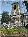
Spring at St Michael & St Wulfad's
The day the new peal of bells rang out for the first time
Image: © Ian Cardinal
Taken: 5 Mar 2013
0.03 miles
6

Ordnance Survey Cut Mark with Bolt
This can be found on the wall of Stone Parish Church.
For more detail see : http://www.bench-marks.org.uk/bm38698
Image: © Peter Wood
Taken: 20 Jul 2016
0.03 miles
7
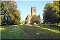
St Michael & St Wulfad, Stone
The parish church of Stone. St Wulfad was supposedly a Mercian prince who was martyred and buried in the town. There is a bit of wild flower meadow in the foreground.
Image: © Bill Boaden
Taken: 19 Sep 2019
0.03 miles
8
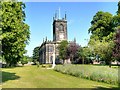
St Michael and St Wulfad's Church, Stone
The Town of Stone was named after the pile of stone raised on the graves of the Princes killed in 665AD by their father, King Wulfhere of Mercia, because of their conversion to Christianity. The Church, built over these stones in 670 AD, was replaced in 1135 AD by an Augustinian Priory, which survived until its dissolution in the reign of Henry VIII. The priory church survived as a place of worship until the building collapsed in 1749 and the present parish church dedicated to St Michael and St. Wulfad, an early example of the Gothic Revival style, was built in the 1750s using stone from the priory. The church is a Grade II* Listed Building (http://www.britishlistedbuildings.co.uk/en-385977-church-of-st-michael-stone-staffordshire British Listed Buildings)
More information at http://www.thepotteries.org/tour/003.htm (Stoke-on-Trent Architecture)
Image: © David Dixon
Taken: 11 Jul 2013
0.03 miles
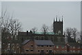
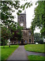
10
St Michael's Church in Stone, Staffordshire
This is the Church of St Michael and St Wulfad. It was built in 1758, designed by William Robinson of Greenwich. It is an early example of Gothic Revival architecture. Previously the site contained the twelfth century Priory Church of St Mary and St Wulfad. http://www.thepotteries.org/tour/003.htm
Image: © Roger Kidd
Taken: 10 Sep 2014
0.03 miles