IMAGES TAKEN NEAR TO
Cheadle Road, LEEK, ST13 7DR
Introduction
This page details the photographs taken nearby to Cheadle Road, ST13 7DR by members of the Geograph project.
The Geograph project started in 2005 with the aim of publishing, organising and preserving representative images for every square kilometre of Great Britain, Ireland and the Isle of Man.

There are currently over 7.5m images from over14,400 individuals and you can help contribute to the project by visiting https://www.geograph.org.uk
Image Map (Loading...)


Getting Data...Please wait
Leaflet Map data © OpenStreetMap
Images are licensed for reuse under creativecommons.org/licenses/by-sa/2.0
Notes
- Clicking on the map will re-center to the selected point.
- The higher the marker number, the further away the image location is from the centre of the postcode.
Image Listing (22 Images Found)
Images are licensed for reuse under creativecommons.org/licenses/by-sa/2.0
Image
Details
Distance
1
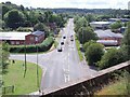
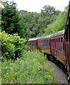
Cheadle Road at Leekbrook, Staffordshire
This is the A520 looking down from a passing train on the Churnet Valley Railway.
Image: © Roger D Kidd
Taken: 1 Aug 2015
0.13 miles
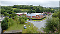
2
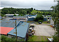
Industrial estate near Leekbrook, Staffordshire
Looking down from the railway embankment by the viaduct.
Image: © Roger D Kidd
Taken: 1 Aug 2015
0.13 miles
3
Leekbrook from above
Leekbrook is a small industrial settlement south of Leek. Leek Brook runs into the River Churnet nearby. This shot was taken from a train crossing the viaduct over the A520.
Image: © Ian Calderwood
Taken: 23 Jul 2011
0.14 miles
5
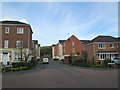
Wardle Gardens, Leekbrook
Recently-built houses, on a former industrial site.
Image: © David Weston
Taken: 12 Oct 2014
0.16 miles
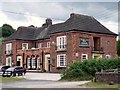
6
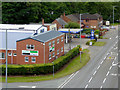
Light industry by Cheadle Road near Leek, Staffordshire
The Esterchem chemicals works is on the corner, seen from a passing train on the bridge.
Image: © Roger D Kidd
Taken: 1 Aug 2015
0.16 miles
7
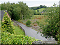
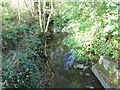
Lane and woodland near Leekbrook, Staffordshire
Looking south from a passing railway train the embankment by the viaduct. Three hundred metres behind the camera hidden by woodland is the sewage works which used this lane to gain access to the public road system.
Image: © Roger D Kidd
Taken: 1 Aug 2015
0.20 miles
9
Railway train approaching Leekbrook Junction, Staffordshire
The train is a Churnet Valley Railway service which operates on one weekend in four between Froghall and Ipstones Loop. https://www.churnet-valley-railway.co.uk/ https://www.churnet-valley-railway.co.uk/
The Cauldon Lowe branch railway line is currently owned by the Moorland and City Railways Company, which has plans to reopen lines as far as Leek and Stoke.
Image: © Roger D Kidd
Taken: 1 Aug 2015
0.21 miles
10
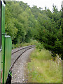
Railway near Leekbrook Junction, Staffordshire
This is looking backwards (north-east) near the sewage lane viaduct. The train is being pulled on the return to Froghall by a diesel unit which helped the small green Polish steam locomotive haul it up the gradient to Ipstones by pushing from the rear.
The line is currently being used as far as the former Ipstones Station by the Churnet Valley Railway Company, but is currently owned by the Moorland and City Railways Company, with plans to reopen lines as far as Leek and Stoke, and agreements likely that CVR will have access to all of its tracks.
Image]
Image: © Roger D Kidd
Taken: 1 Aug 2015
0.22 miles