IMAGES TAKEN NEAR TO
Kings Park, Creek Road, CANVEY ISLAND, SS8 8QT
Introduction
This page details the photographs taken nearby to Kings Park, Creek Road, SS8 8QT by members of the Geograph project.
The Geograph project started in 2005 with the aim of publishing, organising and preserving representative images for every square kilometre of Great Britain, Ireland and the Isle of Man.

There are currently over 7.5m images from over14,400 individuals and you can help contribute to the project by visiting https://www.geograph.org.uk
Image Map
Images are licensed for reuse under creativecommons.org/licenses/by-sa/2.0
Notes
- Clicking on the map will re-center to the selected point.
- The higher the marker number, the further away the image location is from the centre of the postcode.
Image Listing (14 Images Found)
Images are licensed for reuse under creativecommons.org/licenses/by-sa/2.0
Image
Details
Distance
1
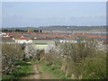
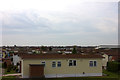
Kings Residential Park
View across the rooves of residential, 'portacabin' type homes. This used to be a holiday park/caravan site.
Image: © Ron Galliers
Taken: 17 Mar 2009
0.05 miles
2
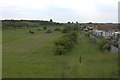
Canvey Heights country park
Newlands estate on the right
Image: © Robert Eva
Taken: 2 Jun 2017
0.07 miles
3
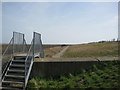
Up and Over
Sea Wall path to the north of Canvey Heights with views across Hadleigh Ray to the Thames Estuary.
Image: © Ron Galliers
Taken: 17 Mar 2009
0.15 miles
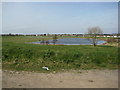
4
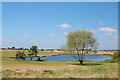
Lake, Newlands
Just outside the entrance to Canvey Heights Country Park.
Image: © Trevor Harris
Taken: 3 Jun 2011
0.15 miles
5
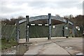
The Gates of Canvey Heights
Country Park. A reclaimed 36 acre landfill site. Now by far the highest point on the entire island.
Image: © John Myers
Taken: 15 Feb 2012
0.16 miles
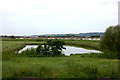
6
Newlands
A grass play area with what is normally a fairly small lake, but much swollen by winter rains.
Image: © Ron Galliers
Taken: 17 Mar 2009
0.16 miles
9
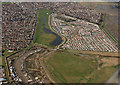
Kings Park Village
Canvey Height Country Park is bottom right. Above that is Kings Park Village.
Image: © terry joyce
Taken: 6 Mar 2009
0.17 miles
10
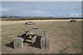
Canvey Heights Country Park
This area must be oversupplied with ignorant morons! Despite the warning labels on each table saying "no fires no BBQs" three out of the five picnic benches have been ruined by idiots using disposable BBQs on wooden tables.....ho hum.
What makes me wonder is why in the early to mid twentieth century this wasn't the first area of Canvey Island to be built on after all it is just about the only bit above sea level!
Image: © Glyn Baker
Taken: 9 Oct 2016
0.18 miles