IMAGES TAKEN NEAR TO
Kitkatts Road, CANVEY ISLAND, SS8 0DY
Introduction
This page details the photographs taken nearby to Kitkatts Road, SS8 0DY by members of the Geograph project.
The Geograph project started in 2005 with the aim of publishing, organising and preserving representative images for every square kilometre of Great Britain, Ireland and the Isle of Man.

There are currently over 7.5m images from over14,400 individuals and you can help contribute to the project by visiting https://www.geograph.org.uk
Image Map
Images are licensed for reuse under creativecommons.org/licenses/by-sa/2.0
Notes
- Clicking on the map will re-center to the selected point.
- The higher the marker number, the further away the image location is from the centre of the postcode.
Image Listing (9 Images Found)
Images are licensed for reuse under creativecommons.org/licenses/by-sa/2.0
Image
Details
Distance
1
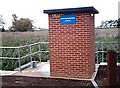
Thorney Bay Pumping Station
Keeping Canvey dry.
Image: © John Myers
Taken: 24 Sep 2006
0.11 miles
2
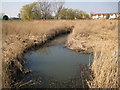
Canvey Island: Thorneycreek Fleet
Thorneycreek Fleet is one of the main natural drains on Canvey Island. This is the view from the Thorney Bay Pumping Station where excess water is pumped out through the sea defence wall into the Thames estuary. Old Victorian Ordnance Survey maps show it as Thornycreek Fleet, without the "e", with a discharge into Thorny Bay.
Image: © Nigel Cox
Taken: 8 Mar 2011
0.12 miles
3
Canvey Island: Thorneycreek Fleet reedbed
Successive editions of old large scale Ordnance Survey maps have shown a pond that has progressively decreased in size in this location. The latest satellite imagery shows that the pond has now silted up entirely, and this extensive and ecologically important reedbed has now colonized the whole site.
The Thorneycreek Fleet pumping station building with its green door, from near which Image was taken, is just visible to the far right of the photograph.
Image: © Nigel Cox
Taken: 8 Mar 2011
0.14 miles
4
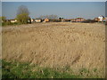
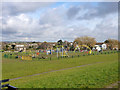
Car Park, Thorney Bay, Canvey Island
Prior to the 1953 floods and subsequent sea defence improvement, the green area to the left of the long path was on the sea side of the sea wall and was saltings. The path follows the line of the old sea wall.
Image: © Robin Webster
Taken: 21 Feb 2015
0.18 miles
5
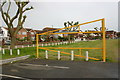
Play area, Thorney Bay, Canvey Island
Prior to the 1953 floods and subsequent sea defence improvement, this green area was on the sea side of the sea wall and was saltings. The mapped public footpath follows the line of the old sea wall.
Image: © Robin Webster
Taken: 21 Feb 2015
0.20 miles
6
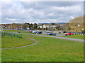
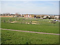
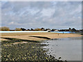
Western Esplanade, Canvey Island
Taken from the car park at Thorney Bay.
Image: © David Kemp
Taken: 12 May 2018
0.20 miles
9
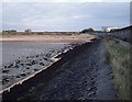
Thorney Bay, Canvey Island
For some reason the seaward face of the sea wall is painted white around the bay, and has been for some years.
Image: © Robin Webster
Taken: 21 Feb 2015
0.24 miles