IMAGES TAKEN NEAR TO
Rushbottom Lane, BENFLEET, SS7 4EA
Introduction
This page details the photographs taken nearby to Rushbottom Lane, SS7 4EA by members of the Geograph project.
The Geograph project started in 2005 with the aim of publishing, organising and preserving representative images for every square kilometre of Great Britain, Ireland and the Isle of Man.

There are currently over 7.5m images from over14,400 individuals and you can help contribute to the project by visiting https://www.geograph.org.uk
Image Map
Images are licensed for reuse under creativecommons.org/licenses/by-sa/2.0
Notes
- Clicking on the map will re-center to the selected point.
- The higher the marker number, the further away the image location is from the centre of the postcode.
Image Listing (22 Images Found)
Images are licensed for reuse under creativecommons.org/licenses/by-sa/2.0
Image
Details
Distance
1
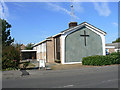
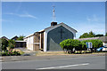
St George's church, New Thundersley
This aerial photo was taken in 1987, twenty-two years before the more recent one of the church, taken in 2009 Image The road in front of the church is Rushbottom Lane. The buildings just visible to the right are of Woodham Lea Primary School.
Image: © Edward Clack
Taken: 17 Jun 1987
0.02 miles
5
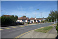
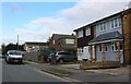
Bungalows on Rushbottom Lane
On the west side.
Image: © Robin Webster
Taken: 11 Sep 2016
0.06 miles
6
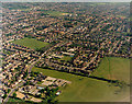
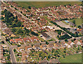
Western parts of Benfleet: New Thundersley and Tarpots
This wide view shot covers the westernmost parts of New Thundersley. The road running from bottom left towards the centre is Rushbottom Lane. There are two primary schools visible here: Montgomerie, towards the bottom left, and Woodham Lea, almost in the centre.
Image: © Edward Clack
Taken: 20 May 1987
0.06 miles
7
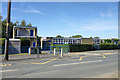
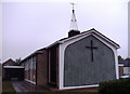
Woodham Ley Primary School
On Rushbottom Lane. What is presumably the boiler house on the left has an odd upper storey, with a door opening on to a space lacking any railings. Was there a fire destroying the wall panel?
Image: © Robin Webster
Taken: 11 Sep 2016
0.07 miles
8
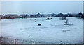
Thundersley Recreation Ground
This area is well-used in good weather, but on a snowy January morning, there were just a few energetic dogs and their walkers. The view is from the upper window of The Tyrells health centre Image
Image: © John Rostron
Taken: 6 Jan 2010
0.13 miles
9
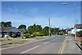
Rushbottom Lane, New Thundersley
Looking north.
Image: © Robin Webster
Taken: 11 Sep 2016
0.14 miles