IMAGES TAKEN NEAR TO
The Finches, BENFLEET, SS7 3LR
Introduction
This page details the photographs taken nearby to The Finches, SS7 3LR by members of the Geograph project.
The Geograph project started in 2005 with the aim of publishing, organising and preserving representative images for every square kilometre of Great Britain, Ireland and the Isle of Man.

There are currently over 7.5m images from over14,400 individuals and you can help contribute to the project by visiting https://www.geograph.org.uk
Image Map
Images are licensed for reuse under creativecommons.org/licenses/by-sa/2.0
Notes
- Clicking on the map will re-center to the selected point.
- The higher the marker number, the further away the image location is from the centre of the postcode.
Image Listing (14 Images Found)
Images are licensed for reuse under creativecommons.org/licenses/by-sa/2.0
Image
Details
Distance
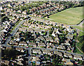
1
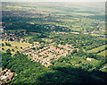
Aerial view of the 'Finches' estate, Thundersley
The 'Finches' is a small estate lies to the west of Thundersley Common. In the picture, the northern part of Thundersley Common occupies the lower right. The Finches is a winding road that occupies much of this estate just below centre.
Image: © Edward Clack
Taken: 5 Jun 1987
0.04 miles
2
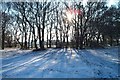
Thundersley Great Common in Winter
Winter sun shining through trees on Thundersley Great Common.
Image: © Dave Playfair
Taken: 28 Dec 2005
0.10 miles
3
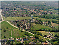
Aerial view of the water Tower and Thundersley Common
The Water Tower is a conspicuous feature just right of centre. The road just below is great Burches Road. The one across the lower left is he Common, joining Common Approach just above centre-left.
Image: © Edward Clack
Taken: 8 May 1987
0.10 miles
4
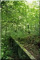
Thundersley Common Ruin
The remains of this cinder block wall seem to be the remains of a garage or barn . There are two parallel walls 56’6” long and 22’6” apart. Any ideas of what business used to be carried on here?
Image: © Glyn Baker
Taken: 18 Sep 2010
0.13 miles
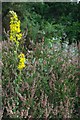
5
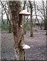
Birch Polypore - Thundersley Great Common
Piptoporus betulinus on dying silver birch. A surprising number of these fungi were present on the common in March attesting to the longevity of the fruiting body of this species.
Image: © John Myers
Taken: 28 Mar 2007
0.14 miles
6
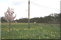
Common in Springtime
Thundersley Great Common in the Spring.
Photo taken from where Common Approach joins the Common.
Image: © terry joyce
Taken: 1 Apr 2008
0.18 miles
7
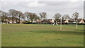
Recreation Ground
This is the Recreation Ground next to Thundersley Great Common.
Photo taken from Common Lane.
Image: © terry joyce
Taken: 1 Apr 2008
0.18 miles
8
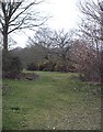
Thundersley Great Common
Open woodland/heath much frequented by dog walkers. An important Essex heathland SSSI.
Image: © John Myers
Taken: 28 Mar 2007
0.20 miles
9
Aerial view of Cedar Hall and southern Thundersley Common
Cedar Hall is the road running along the left of the image (rather than a stately home). The road running left-to-right along the lower part is Cedar Park Close. Common Approach runs from the upper left towards the centre-right, then bends down toward the bottom. Thundersley Common is the green area on the right.
Image: © Edward Clack
Taken: 16 Oct 1987
0.21 miles
10
Heather on Thundersley Common
The darker foliage growing up through the heather are oak saplings. The heath will once more revert to woodland if active management ever ceases.
Image: © Glyn Baker
Taken: 18 Sep 2010
0.21 miles