
IMAGES TAKEN NEAR TO
Chesterfield Avenue, BENFLEET, SS7 3HW
Introduction
This page details the photographs taken nearby to Chesterfield Avenue, SS7 3HW by members of the Geograph project.
The Geograph project started in 2005 with the aim of publishing, organising and preserving representative images for every square kilometre of Great Britain, Ireland and the Isle of Man.

There are currently over 7.5m images from over14,400 individuals and you can help contribute to the project by visiting https://www.geograph.org.uk
Image Map
Images are licensed for reuse under creativecommons.org/licenses/by-sa/2.0
Notes
- Clicking on the map will re-center to the selected point.
- The higher the marker number, the further away the image location is from the centre of the postcode.
Image Listing (26 Images Found)
Images are licensed for reuse under creativecommons.org/licenses/by-sa/2.0
Image
Details
Distance
1
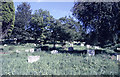
St Peter's Churchyard, Thundersley, looking south
This churchyard (graveyard) sits on the brow of a hill, then slopes down to the west. The start of this can just be seen to the right of the picture. The north (here) and south ends are wooded to varying amounts.
Image: © John Rostron
Taken: Unknown
0.09 miles
2
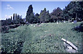
St Peter's Churchyard, Thundersley, looking north
This is the open central section of the churchyard, set on the brow of a scarp slope to the left. In the background (north) are a number of planted conifers. The church itself is behind the trees to the top left.
Image: © John Rostron
Taken: Unknown
0.10 miles
4
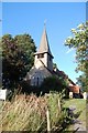
St Peter's Parish Church, Thundersley
St Peter's stands at the top of quite a steep hill (behind me as I took the photo). The white notice explains that the fenced area of the churchyard (in the foreground) has been closed to the public due to subsidence.
Image: © Trevor Harris
Taken: 1 Aug 2008
0.12 miles
5

St Peter, Thundersley - west elevation
From this end the church still has the look of the small medieval church it once was. A much larger extension, visible beyond the porch, was added in 1965 and replaced the chancel of 1885.
Image: © David Kemp
Taken: 13 Mar 2026
0.12 miles
6
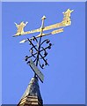
St. Peter's, Thundersley
Weathervane
Image: © Julieanne Savage
Taken: 20 Jan 2007
0.12 miles
7
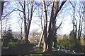
Slip Sliding Away 2
Here is another shot of the plummeting graveyard at St, Peter's, Thundersley. It is actually a real shame. The estate behind is one of my favourite places in the world - Tarpots. Perhaps that is why no-one is doing much to stop the landslide.
Image: © Julieanne Savage
Taken: 20 Jan 2007
0.12 miles
8
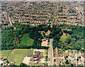
Aerial view of Kingston School and St Peter's Church, Thundersley
Kingston Primary School lies at the bottom centre, with Church Road to the right. The road opposite the school is Grasmere Road. The wood to the centre-left is Coombe Wood. The edge of the woodland marks the escarpment (also seen in Image). The housing beyond is New Thundersley. The Church Road can be seen continuing towards to top centre.
Image: © Edward Clack
Taken: 6 Jun 1987
0.12 miles
9
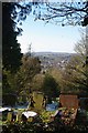
Thundersley Cemetery
Looking towards Wistley Heights across Thundersley Cemetery
Image: © Glyn Baker
Taken: 1 Jan 2010
0.13 miles
10
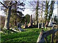
Slip sliding away!
This is the graveyard at St. Peter's, Thundersley. Big notices say this place is currently closed to the public due to subsidence. Some of these graves are very old and are literally tumbling down the hill towards Tarpots! The fences and supports they have put up aren't very good and the whole thing is crumbling. Major work is needed here to save this graveyard.
Image: © Julieanne Savage
Taken: 20 Jan 2007
0.13 miles