IMAGES TAKEN NEAR TO
Rhoda Road North, BENFLEET, SS7 3EH
Introduction
This page details the photographs taken nearby to Rhoda Road North, SS7 3EH by members of the Geograph project.
The Geograph project started in 2005 with the aim of publishing, organising and preserving representative images for every square kilometre of Great Britain, Ireland and the Isle of Man.

There are currently over 7.5m images from over14,400 individuals and you can help contribute to the project by visiting https://www.geograph.org.uk
Image Map
Images are licensed for reuse under creativecommons.org/licenses/by-sa/2.0
Notes
- Clicking on the map will re-center to the selected point.
- The higher the marker number, the further away the image location is from the centre of the postcode.
Image Listing (33 Images Found)
Images are licensed for reuse under creativecommons.org/licenses/by-sa/2.0
Image
Details
Distance
1
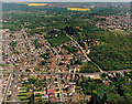
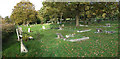
Aerial view of the bottom of Bread-and-Cheese Hill, Benfleet
The road running across the image, just below centre, is the A13 (London Road). At the left there is an incline known as the Bread-and-Cheese Hill. This hill can be seen from the bottom in Image The roads running north from the London Road are Spencer Road (extreme left), Stanley Road, Downer Road North and Rhoda Road North. The roads to the south are (from the left) Felstead Road, Downer Road and Rhoda Road (unmade, amid scrubland). The road running obliquely from centre-left to above centre is Thundersley Church Road. The woodland at centre-left is Coombe Wood.
Image: © Edward Clack
Taken: 8 May 1987
0.05 miles
2
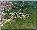
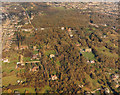
Aerial view of Coombe Wood and escarpment, Benfleet
Coombe Wood occupies the bottom and right of the picture here. It sits on the Claygate and Bagshot beds. The built-up areas to the left lie on the lower-lying London Clay. There is an escarpment between these running from the lower left of the image to the upper right. The road running from the lower left (Rhoda Road North) lies approximately at the top of the slope. The road from the mid-left running parallel (Downer Road North) is approximately at the bottom. St Peter's Church lies in the upper right, with the churchyard below and left.
Image: © Edward Clack
Taken: 8 May 1987
0.07 miles
3
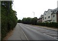
Benfleet: Downer Road North
A road named after me! (Joking, of course.) The building with the skip in the car park is an eye clinic.
Image: © Chris Downer
Taken: 13 Sep 2008
0.12 miles
4
St Peter's Churchyard, Thundersley, looking north
This is a similar view to that of Image, taken in Summer 1987, before the hurricane. Many of the conifers visible then came down, and since then other trees have grown up. Image shows an aerial view including the churchyard, taken in the spring of 1987.
Image: © John Rostron
Taken: 4 Nov 2010
0.13 miles
5
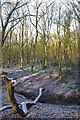
A Coombe Wood Stream
A fallen tree over a stream in Coombe Wood, this area of Thundersley Woods managed by Castlepoint Council was granted “Village Green” status in 2007.
Image: © Glyn Baker
Taken: 1 Jan 2010
0.14 miles
6
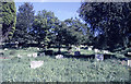
St Peter's Churchyard, Thundersley, looking south
This churchyard (graveyard) sits on the brow of a hill, then slopes down to the west. The start of this can just be seen to the right of the picture. The north (here) and south ends are wooded to varying amounts.
Image: © John Rostron
Taken: Unknown
0.14 miles
7
Aerial view of Coombe Wood and plotlands to the south, Benfleet
This photo shows some nice autumnal colours in October 1987. Coombe Wood is the woodland in the upper third of the photo. The road below it is the A13 (London Road) and the road to the right is Rhoda Road North (unmade). Much of the land below this is well-wooded plotland, mostly secondary woodland, though there are one or two patches thought to be ancient.
Image: © Edward Clack
Taken: 16 Oct 1987
0.14 miles
8
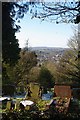
Thundersley Cemetery
Looking towards Wistley Heights across Thundersley Cemetery
Image: © Glyn Baker
Taken: 1 Jan 2010
0.15 miles