
IMAGES TAKEN NEAR TO
Falbro Crescent, BENFLEET, SS7 2SF
Introduction
This page details the photographs taken nearby to Falbro Crescent, SS7 2SF by members of the Geograph project.
The Geograph project started in 2005 with the aim of publishing, organising and preserving representative images for every square kilometre of Great Britain, Ireland and the Isle of Man.

There are currently over 7.5m images from over14,400 individuals and you can help contribute to the project by visiting https://www.geograph.org.uk
Image Map
Images are licensed for reuse under creativecommons.org/licenses/by-sa/2.0
Notes
- Clicking on the map will re-center to the selected point.
- The higher the marker number, the further away the image location is from the centre of the postcode.
Image Listing (14 Images Found)
Images are licensed for reuse under creativecommons.org/licenses/by-sa/2.0
Image
Details
Distance
1
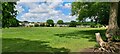
Part of John H Burrows Recreation Ground
From Chelmsford Chronicle Friday 17th July 1936
RECREATION GROUND FOR HADLEIGH
The John H. Burrows Recreation Ground at Hadleigh was opened on Saturday by Mrs. J. H. Burrows. Benfleet Urban Council acquired Solbys ——- where the late Mr. J. H. Burrows J.P., C.A. resided for many years—and the grounds, consisting of about 9 ½ acres, for £3,700. One of the fields is already used for cricket, and it is the intention to lay out the bulk of the remaining land for games. The use to which the house is to be put has yet to be decided. Mrs. Burrows, who was accompanied by Mr. Roland Burrows, K.C., and Mrs. Roland Burrows, Dr. Arthur Burrows, and Mr. R. T. F. Burrows, unveiled the board which bears the name of the ground. . The Chairman of the Council (Mr. H. R. Tutt, J.P) paid tribute to the work of the late Ald. John Burrows, the whole of whose life, he said, was devoted to the service of his fellow men.
Image: © Chris Morgan
Taken: 5 Jun 2021
0.07 miles
2
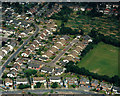
Aerial view of Broomfield and Springfield, Hadleigh
This area lies between West Wood and Daws Heath Road. The road across the bottom is Falbro Crescent. Broomfield runs along the left-hand side, with Springfield running off this towards the centre. The green space to the lower right is the north end of the John Burrows Recreation Ground, with the allotments above it.
Image: © Edward Clack
Taken: 13 Jun 1988
0.08 miles
3
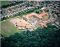
Aerial view of Westwood School and part of West Wood, Benfleet
Westwood Primary School lies in the centre, next to west Wood in the lower part. The road in the upper left is Falbro Crescent, the road in the upper right (right of the school) is Beresford Gardens.
Image: © Edward Clack
Taken: 10 Jul 1988
0.13 miles
4
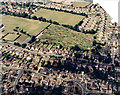
Aerial view between Hadleigh and Daws Heath
This is the area just north of Image The road across the centre is Daws Heath Road, running between Hadleigh to the left (south) and Daws Heath to the right (north). The patchwork area just above centre are allotments, seen at ground level in Image To the left of these, the open area is part of the John Burrows recreation grounds. The square at the left centre is a bowling green. The date given here is approximate.
Image: © Edward Clack
Taken: Unknown
0.16 miles
5
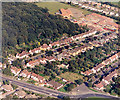
Aerial view of Westwood School and West Wood
The wood at the top left is the south-west corner of West Wood. Westwood School lies above right of this. The road running below and right of the wood is Beresford Gardens. The road to the lower left is the A129 (Rayleigh Road). The Hadleigh roundabout (Victoria House Corner) Image is just visible at the lower right.
Image: © Edward Clack
Taken: 18 Sep 1987
0.16 miles
6
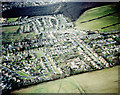
Aerial view of parts of Daws Heath and West Wood
This is the area just north of that seen in Image Daws Heath Road runs across the centre. The wood in the background is West Wood, the patch of houses in front of it are known as the west Wood Estate. The patchy area to the left, just above the centre, are the allotments, seen at ground level in Image
Image: © Edward Clack
Taken: Unknown
0.17 miles
7
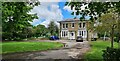
Solby's House, Hadleigh
From Chelmsford Chronicle Friday 17th July 1936
RECREATION GROUND FOR HADLEIGH
The John H. Burrows Recreation Ground at Hadleigh was opened on Saturday by Mrs. J. H. Burrows. Benfleet Urban Council acquired Solbys ——- where the late Mr. J. H. Burrows J.P., C.A. resided for many years—and the grounds, consisting of about 9 ½ acres, for £3,700. One of the fields is already used for cricket, and it is the intention to lay out the bulk of the remaining land for games. The use to which the house is to be put has yet to be decided. Mrs. Burrows, who was accompanied by Mr. Roland Burrows, K.C., and Mrs. Roland Burrows, Dr. Arthur Burrows, and Mr. R. T. F. Burrows, unveiled the board which bears the name of the ground. . The Chairman of the Council (Mr. H. R. Tutt, J.P) paid tribute to the work of the late Ald. John Burrows, the whole of whose life, he said, was devoted to the service of his fellow men.
Image: © Chris Morgan
Taken: 5 Jun 2021
0.18 miles
8
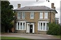
Solby's House, Hadleigh
Solby's is a late 18th Century landowner's country house (named after its first owner, William Solby), now a residential home.
Image: © Trevor Harris
Taken: 1 Aug 2008
0.19 miles
9
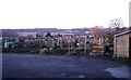
Hadleigh Allotments
These allotments in Hadleigh are to the north of the recreation ground on Heath Road. The houses in the background are in Dalwood Gardens.
Image: © Glyn Baker
Taken: 28 Jan 2006
0.19 miles
10
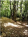
West Wood - Boundary bank and ditch
Ancient wood boundary with large bank and ditch in S.W. corner of wood
Image: © John Myers
Taken: 30 Jul 2006
0.20 miles