IMAGES TAKEN NEAR TO
Arterial Road, RAYLEIGH, SS6 7TR
Introduction
This page details the photographs taken nearby to Arterial Road, SS6 7TR by members of the Geograph project.
The Geograph project started in 2005 with the aim of publishing, organising and preserving representative images for every square kilometre of Great Britain, Ireland and the Isle of Man.

There are currently over 7.5m images from over14,400 individuals and you can help contribute to the project by visiting https://www.geograph.org.uk
Image Map
Images are licensed for reuse under creativecommons.org/licenses/by-sa/2.0
Notes
- Clicking on the map will re-center to the selected point.
- The higher the marker number, the further away the image location is from the centre of the postcode.
Image Listing (28 Images Found)
Images are licensed for reuse under creativecommons.org/licenses/by-sa/2.0
Image
Details
Distance
2
Thundersley Great Common
This is taken from Kingsley Lane at the northern end of the common.
Image: © Trevor Harris
Taken: 9 Oct 2008
0.10 miles
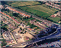
3
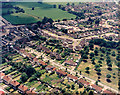
Aerial view of Kingsley Lane and Sandown Road, Thundersley
These two roads run off the Rayleigh Road (A129) just south of the Rayleigh Weir. The Rayleigh Road runs from left to right along the top of the picture. Kingsley Lane runs from the centre-left to the lower right. Sandown Road comes off the Rayleigh Road opposite the fields, runs towards then centre, then bends up towards the upper right. The parkland with scattered trees at the right is the northern end of Thundersley Common.
Image: © Edward Clack
Taken: 5 Jun 1987
0.11 miles
5
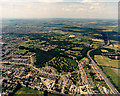
Aerial view of Thundersley Common and the Southend Arterial Road
The Southend Arterial Road (A127) runs from the lower right upwards into the distance (and London). Thundersley Common is hourglass-shaped. The northern part lies just below centre and comprises open parkland with scattered trees and heathland, with a wooded part to the left. The southern part lies to the left of centre, and has some woodland, some scattered trees and some heathland. The narrow waist between is wooded.
Image: © Edward Clack
Taken: 10 Jul 1987
0.13 miles
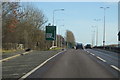
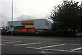
6
Aerial view of south-west of the Rayleigh Weir
The Rayleigh Weir junction is partially visible at the mid-lower right. The London Arterial Road (A127) runs from the Weir to the upper left, and the Rayleigh Road (A129) to the lower left. The road below and parallel to the A127 is Kingsley Lane. The car park to the lower right is that of Sainsbury's Supermarket. The open area bordering the Rayleigh Road now has several retail and light industrial premises.
Image: © Edward Clack
Taken: 5 Jun 1987
0.14 miles
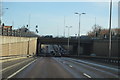
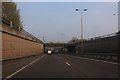
8
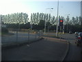
The corner of Rayleigh Road and the A127
Image: © David Howard
Taken: 24 May 2012
0.16 miles
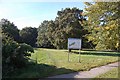
9
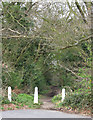
Leafy Lane
This Footpath is at the end of Kingsley Lane. It is heading towards the A127.
Image: © terry joyce
Taken: 1 Apr 2008
0.17 miles