IMAGES TAKEN NEAR TO
Shoeburyness, SOUTHEND-ON-SEA, SS3 9SG
Introduction
This page details the photographs taken nearby to SS3 9SG by members of the Geograph project.
The Geograph project started in 2005 with the aim of publishing, organising and preserving representative images for every square kilometre of Great Britain, Ireland and the Isle of Man.

There are currently over 7.5m images from over14,400 individuals and you can help contribute to the project by visiting https://www.geograph.org.uk
Image Map (Loading...)


Getting Data...Please wait
Leaflet Map data © OpenStreetMap
Images are licensed for reuse under creativecommons.org/licenses/by-sa/2.0
Notes
- Clicking on the map will re-center to the selected point.
- The higher the marker number, the further away the image location is from the centre of the postcode.
Image Listing (104 Images Found)
Images are licensed for reuse under creativecommons.org/licenses/by-sa/2.0
Image
Details
Distance
1
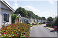
Shoeburyness : Residential park
Large development of factory built chalet-type bungalows.
Image: © Jim Osley
Taken: 28 Jul 2018
0.02 miles
2

Ganesh Festival
Annual event at Shoebury East Beach. Reputed to be one of the largest Ganesh Festivals outside India.
Image: © John Myers
Taken: 11 Sep 2011
0.06 miles
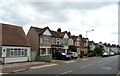
3

Shoeburyness: Old Military Railway from Blackgate Road looking South-southwest
Part of an extensive marshalling yard at the old Shoebury Garrison. The rails are used occasionally and old slam-door rolling stock was stored until recently on MoD land.
Image: © Trevor Durritt
Taken: 11 Jun 2005
0.09 miles
5
Shoeburyness: East Beach seafront
These abandoned and flaking cockle boats sum up the feel of this bleak December sunrise. Photograph was taken midway down East Beach at sunrise. This area has small dunes and deep sand, littered with cockles and shingle. I was struggling to get a foothold in this shot as the sand was absolutely sopping from heavy rainfall in the early hours.
Image: © Julieanne Savage
Taken: 9 Dec 2006
0.11 miles
6
Shoebury East Beach, Kitesurfing
This is towards the Blackgate Road entrance on Shoebury East Beach, that the Kitesurfers use.
The grass area to the right is where the Kitesurfers set up their equipment.
Image: © terry joyce
Taken: 16 Aug 2010
0.11 miles
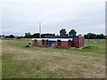
7
Shoebury East Beach, Toilets & Office
The building to the right is one of two sets of Toilets on the beach. There is also an office for the Pier and Foreshore Officer.
Recycle bins neext to the railings.
Image: © terry joyce
Taken: 16 Aug 2010
0.11 miles
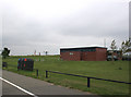
8
Amenity building, Shoebury East Beach
All shuttered up, at least on this side, in August.
Image: © Robin Webster
Taken: 11 Aug 2015
0.12 miles
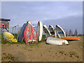
9
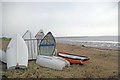
Dinghies & Dunes
Behind the dinghies you can see a hint the natural dunes that would have been all around here before the sea defences were built.
Image: © Glyn Baker
Taken: 22 Jan 2011
0.13 miles
10
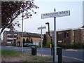
Which Road is Which?
Two Shoeburyness signs appear to be oriented in the same direction. Wakerling Road is 'out' by 90 degrees. the road leading off to the left is Blackgate Road.
Image: © Ian Paterson
Taken: 7 May 2008
0.13 miles