IMAGES TAKEN NEAR TO
Church Road, SOUTHEND-ON-SEA, SS3 9HA
Introduction
This page details the photographs taken nearby to Church Road, SS3 9HA by members of the Geograph project.
The Geograph project started in 2005 with the aim of publishing, organising and preserving representative images for every square kilometre of Great Britain, Ireland and the Isle of Man.

There are currently over 7.5m images from over14,400 individuals and you can help contribute to the project by visiting https://www.geograph.org.uk
Image Map (Loading...)


Getting Data...Please wait
Leaflet Map data © OpenStreetMap
Images are licensed for reuse under creativecommons.org/licenses/by-sa/2.0
Notes
- Clicking on the map will re-center to the selected point.
- The higher the marker number, the further away the image location is from the centre of the postcode.
Image Listing (31 Images Found)
Images are licensed for reuse under creativecommons.org/licenses/by-sa/2.0
Image
Details
Distance
1
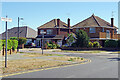
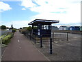
Church Road, Shoeburyness
The western end of Church Road is seen here where it meets Maplin Way, a short distance inland from the seafront. Note the distinctive style of road name signs used in Southend on Sea.
Image: © Stephen McKay
Taken: 11 Aug 2022
0.03 miles
2
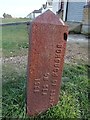
Old Boundary Marker
Municipal Boundary Marker in front of beach huts between the road and the beach opposite junction of Maplin Way and Shoebury Common Road. Now entirely in the boundary of Southend on Sea unitary authority. In raised lettering BOROUGH OF SOUTHEND / ON SEA / 1908 and URBAN DISTRICT / OF SHOEBURYNESS.
Milestone Society National ID: EX_SOUS07pb
Image: © R Rothwell
Taken: 10 Apr 2020
0.03 miles
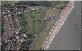
3
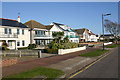
Thorpe Bay Gardens, Thorpe Bay
Thorpe Bay Gardens is one of the most expensive roads in Southend. The contrast between this and some of the other roads in the area is instructive. As is so often the case, respective postcodes mark the difference. Whereas this road is (just) within the SS1 area things look very different just over the border in parts of SS3. Compare this for example with Image which lies just over ten minutes' walk away.
Image: © David Kemp
Taken: 22 Feb 2018
0.12 miles
4
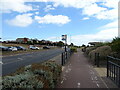
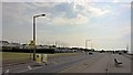
National Cycle Route 16 towards Shoebury Common
Beside Thorpe Esplanade (B1016).
Image: © JThomas
Taken: 23 Aug 2022
0.14 miles
7
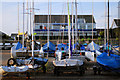
Thorpe Bay Yacht Club
The boats have to be wheeled over the busy road before they can reach the water.
Image: © william
Taken: 4 Jul 2009
0.16 miles
8
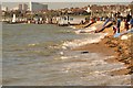
Shoebury Tidal Erosion
Where has the beach gone? A few weeks ago there was a mini digger on the beach moving sand. The high tides are doing their worst with nature assisted by man.
Image: © Tony Peacock
Taken: 16 Feb 2014
0.16 miles
9
Boats crossing
Thorpe Bay Sailing Club
Image: © Chris Morgan
Taken: 12 Jun 2015
0.17 miles
10
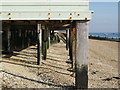
Solid Foundations
Although these look more like the wooden piles used for piers, they are in fact the support for beach huts at Shoebury.
Image: © John Winfield
Taken: 4 Oct 2007
0.17 miles