IMAGES TAKEN NEAR TO
Barling Road, SOUTHEND-ON-SEA, SS3 0ND
Introduction
This page details the photographs taken nearby to Barling Road, SS3 0ND by members of the Geograph project.
The Geograph project started in 2005 with the aim of publishing, organising and preserving representative images for every square kilometre of Great Britain, Ireland and the Isle of Man.

There are currently over 7.5m images from over14,400 individuals and you can help contribute to the project by visiting https://www.geograph.org.uk
Image Map
Images are licensed for reuse under creativecommons.org/licenses/by-sa/2.0
Notes
- Clicking on the map will re-center to the selected point.
- The higher the marker number, the further away the image location is from the centre of the postcode.
Image Listing (13 Images Found)
Images are licensed for reuse under creativecommons.org/licenses/by-sa/2.0
Image
Details
Distance
1
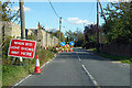
Roadworks on Barling Road
Through Stonebridge.
Image: © Robin Webster
Taken: 1 Oct 2018
0.06 miles
2
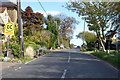
Barling Road, Stonebridge
Towards Barling.
Image: © Robin Webster
Taken: 1 Oct 2018
0.13 miles
3
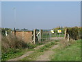
Waterworks at Stonebridge
This is an Anglian Water treatment works on the footpath that runs from Stonebridge to Butler’s Farm. The footpath continues to the right of the fence.
Image: © Glyn Baker
Taken: 16 Oct 2005
0.14 miles
4
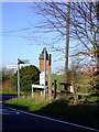
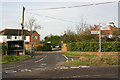
Barrow Hall junction
At the bottom of Stonebridge hill. You can go towards Southend, Rochford or Barling from here. The right hand junction leads to Barling church. Image
Image: © Julieanne Savage
Taken: 10 Dec 2006
0.19 miles
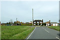
5
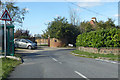
Road junction near High House Farm, Stonebridge
Mucking Hall Road is to the left and Barling Road is in the foreground.
Image: © David Kemp
Taken: 24 Nov 2014
0.20 miles
6
Bend on Mucking Hall Road
A bend where it turns north, just after the turn-off for the road. Thereafter it is remarkable for its straightness.
Image: © Robin Webster
Taken: 1 Oct 2018
0.21 miles
7
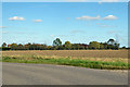
Ploughed field, Stonebridge
Beyond is Burtons Farm.
Image: © Robin Webster
Taken: 1 Oct 2018
0.21 miles
9
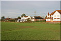
High House Farm
An odd name, the house is not particularly high, the road junction in front of it is 12 m above sea level. The house does not look very old, perhaps it replaced an older, taller house.
Image: © Robin Webster
Taken: 6 Apr 2018
0.22 miles
10

Stonebridge and Barling Magna
This is the Barling Road entering the Stonebridge.
Image: © terry joyce
Taken: 20 Oct 2010
0.23 miles