IMAGES TAKEN NEAR TO
Star Lane, SOUTHEND-ON-SEA, SS3 0FL
Introduction
This page details the photographs taken nearby to Star Lane, SS3 0FL by members of the Geograph project.
The Geograph project started in 2005 with the aim of publishing, organising and preserving representative images for every square kilometre of Great Britain, Ireland and the Isle of Man.

There are currently over 7.5m images from over14,400 individuals and you can help contribute to the project by visiting https://www.geograph.org.uk
Image Map (Loading...)


Getting Data...Please wait
Leaflet Map data © OpenStreetMap
Images are licensed for reuse under creativecommons.org/licenses/by-sa/2.0
Notes
- Clicking on the map will re-center to the selected point.
- The higher the marker number, the further away the image location is from the centre of the postcode.
Image Listing (16 Images Found)
Images are licensed for reuse under creativecommons.org/licenses/by-sa/2.0
Image
Details
Distance
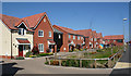
1
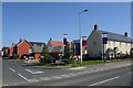
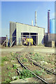
Waters Edge@Wyborne Park, Great Wakering
The Waters Edge development was launched in 2014 with the first residents moving in about two years later. This is all in stark contrast to how the area was when it was the site of the former Star Lane brickworks. Hence the names - Sandy Crescent, Kiln Way and Brick Road - of the new roads. Geographs including Image and Image show how the area used to look. Taken on the corner of Star Lane and Sandy Crescent. "Waters Edge" refers not to the beaches of nearby Southend but to some flooded claypits at the end of Sandy Crescent.
Image: © David Kemp
Taken: 20 Apr 2019
0.02 miles
2
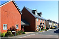
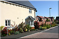
Kiln Way, Great Wakering
This shows the Waters Edge development that was launched in 2014 with the first residents moving in about two years later. This is all in stark contrast to how the area was when it was the site of the former Star Lane brickworks. Hence the names - Sandy Crescent, Kiln Way and Brick Road - of the new roads. Geographs including Image and Image show how the area used to look.
Image: © David Kemp
Taken: 20 Apr 2019
0.03 miles
4
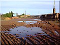
Star Lane brickworks
Here you can see just how muddy this place is, but the mud is a lovely rich orange colour, the same as the bricks. Brick making was the main industry during the Industrial Revolution and early 20th Century around this part of Great Wakering.
Image: © Julieanne Savage
Taken: 14 Jan 2007
0.03 miles
5
Clay delivery shed, Star Lane Brickworks, 1989
Locomotive (Alan Keef 40SD530 of 1987) and skips are shut away for the weekend. As far as I could make out the line went no further into the works. There was another locomotive in the shed on a short branch to the left.
Image: © Robin Webster
Taken: Unknown
0.05 miles
6
Brick Road, Great Wakering
This shows the Waters Edge development that was launched in 2014 with the first residents moving in about two years later. This is all in stark contrast to how the area was when it was the site of the former Star Lane brickworks. Hence the names - Sandy Crescent, Kiln Way and Brick Road - of the new roads. Earlier Geographs including Image and Image show the previous uses of the site.
Image: © David Kemp
Taken: 20 Apr 2019
0.06 miles
7
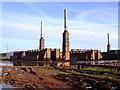
The Brickworks
In Star Lane. Brick-making was the main Victorian industry of Great Wakering. The site persists today and is very distinctive.
Image: © Julieanne Savage
Taken: 14 Jan 2007
0.08 miles
8
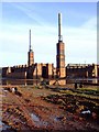
Star Lane Brickworks
This site can be seen for miles around. Some people say the four chimneys have a look of Battersea around them. The mud is a rich orange and is very thick.
Image: © Julieanne Savage
Taken: 14 Jan 2007
0.08 miles
9
Sandy Crescent, Great Wakering
This shows the Waters Edge development that was launched in 2014 with the first residents moving in about two years later. This is all in stark contrast to how the area was when it was the site of the Star Lane brickworks. Hence the names - Sandy Crescent, Kiln Way and Brick Road - of the new roads. Geographs including Image and Image show how the area used to look. "Waters Edge" refers not to the beaches of nearby Southend but to some flooded claypits at the end of Sandy Crescent.
Image: © David Kemp
Taken: 20 Apr 2019
0.08 miles
10
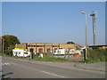
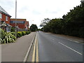
BT in Star Lane
This is a telephone exchange on the B1017 Star Lane
Image: © Glyn Baker
Taken: 16 Oct 2005
0.12 miles