IMAGES TAKEN NEAR TO
Laurence Industrial Estate, Eastwoodbury Lane, SOUTHEND-ON-SEA, SS2 6RH
Introduction
This page details the photographs taken nearby to Laurence Industrial Estate, Eastwoodbury Lane, SS2 6RH by members of the Geograph project.
The Geograph project started in 2005 with the aim of publishing, organising and preserving representative images for every square kilometre of Great Britain, Ireland and the Isle of Man.

There are currently over 7.5m images from over14,400 individuals and you can help contribute to the project by visiting https://www.geograph.org.uk
Image Map
Images are licensed for reuse under creativecommons.org/licenses/by-sa/2.0
Notes
- Clicking on the map will re-center to the selected point.
- The higher the marker number, the further away the image location is from the centre of the postcode.
Image Listing (27 Images Found)
Images are licensed for reuse under creativecommons.org/licenses/by-sa/2.0
Image
Details
Distance
1
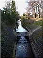
Eastwood Brook
This picture shows Eastwood Brook constrained in concrete embankments as it flows through an industrial estate. The photo was taken looking due west from the B1013 Cherry Orchard Way.
Image: © Glyn Baker
Taken: 29 Jan 2006
0.05 miles
2
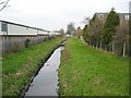
Eastwood Brook
A section of the stream that has been canalised between housing and the industrial estate.
Image: © John Allan
Taken: 22 Mar 2007
0.09 miles
3
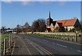
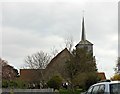
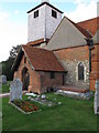
St Laurence Church, Eastwood
This picture shows St Laurence Church, Eastwood. Parts of the building date back to the 12th century with some recycled roman bricks being used in the construction. The church stands inside the ATC controlled area of Southend Airport, a few yards from the end of the main runway. To the left of the picture can be seen the barriers that close off the road when a large aircraft is due to land. The red sign outside the church is not for the parish notices it tells motorists, “for your own safety if the barriers are down do not move your car”. It has been suggested that the church could be pulled down and reconstructed 100 yards away to facilitate airport expansion. To find out more see http://www.ecclsoc.org/eastwood.html
Image: © Glyn Baker
Taken: 29 Jan 2006
0.09 miles
4
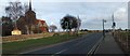
St Laurence Church, Eastwood
This photo shows the proximity of St Laurence Church to Southend Airport’s runway. There is a “crash gate” on the left of the picture at the end of the churchyard wall. The barriers close when large aircraft take off or land.This photo was taken looking East.
Image: © Glyn Baker
Taken: 10 Feb 2006
0.09 miles
5
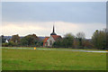
St Laurence, another view
This photo of St Laurence and All Saints Church at Eastwood was taken from Southend Flying Club.
You can see that it is fairly close to the Runway.
It is about 99 metres to the very end of the Runway and about 225 metres from the Threshold. The Threshold is the point on the Runway at which planes are allowed to land after.
Image: © terry joyce
Taken: 8 Nov 2007
0.09 miles
6
St Laurence and All Saints Church
Standing at the end of the runway at Southend Airport.
Image: © Trevor Harris
Taken: 10 Mar 2014
0.12 miles
7
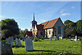
Eastwood church
St. Laurence and All Saints is a grade I listed building, 12th to 17th century. Its churchyard abuts Southend Airport, not far from the runway, although the airport is not the busiest.
Image: © Robin Webster
Taken: 1 Oct 2018
0.13 miles
8
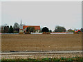
St Laurence and All Saints Church
This is looking across the end of the runway extension at Southend Airport to St Laurence and All Saints Church.
Taken from the path above the new link road.
Image: © terry joyce
Taken: 28 Nov 2011
0.13 miles
9
St Laurence church
The church is right next to the end of the runway at Southend Airport.
Image: © william
Taken: 18 Sep 2010
0.13 miles
10
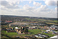
Take Off again
This was the second photo I was able to take when I was Co Pilot on a flight to Lydd.
The building with the fir trees and a marquee is the Essex County Hotel.
See Image
The open area of land in the centre of the photo is in Cherry Orchard Way.
I believe industrial units are going to be built there.
Image: © terry joyce
Taken: 2 Mar 2007
0.13 miles