IMAGES TAKEN NEAR TO
The Wheelwrights, SOUTHEND-ON-SEA, SS2 5RD
Introduction
This page details the photographs taken nearby to The Wheelwrights, SS2 5RD by members of the Geograph project.
The Geograph project started in 2005 with the aim of publishing, organising and preserving representative images for every square kilometre of Great Britain, Ireland and the Isle of Man.

There are currently over 7.5m images from over14,400 individuals and you can help contribute to the project by visiting https://www.geograph.org.uk
Image Map
Images are licensed for reuse under creativecommons.org/licenses/by-sa/2.0
Notes
- Clicking on the map will re-center to the selected point.
- The higher the marker number, the further away the image location is from the centre of the postcode.
Image Listing (15 Images Found)
Images are licensed for reuse under creativecommons.org/licenses/by-sa/2.0
Image
Details
Distance
1
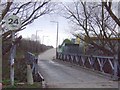
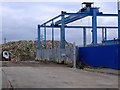
Temple Farm Industrial Estate, Southend
This gridsquare comprises part of a large cemetery, some open farmland and Temple Farm Industrial Estate. This photograph shows the latter at the junction of The Wheelwrights and Craftsmans Square looking north-east.
Image: © David Kemp
Taken: 9 Feb 2006
0.06 miles
2
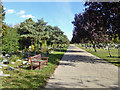
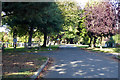
Road in Sutton Road Cemetery
A large, cosmopolitan cemetery.
Image: © Robin Webster
Taken: 1 Oct 2018
0.15 miles
3
In Sutton Road Cemetery
A large, cosmopolitan cemetery.
Image: © Robin Webster
Taken: 1 Oct 2018
0.17 miles
4
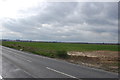
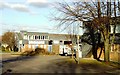
Field by Sutton Road
Flat, featureless landscape. Part of Temple Farm industrial estate can be seen towards the left. Taken from outside The Old Rectory.
Image: © Trevor Harris
Taken: 18 Mar 2014
0.17 miles
5
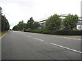
Southend: Chandlers Way
The very broad expanse of Chandlers Way leads off Sutton Road into the Temple Farm industrial estate on the very edge of Southend. Despite its width the road has a double yellow line parking restriction on both sides. The names of the roads in the estate are of old occupations, such as wheelwrights, cordwainers, etc.. This road is also an example of what is shown on Ordnance Survey 1:50,000 scale maps with solid red circles as an "Other route with public access"
Image: © Nigel Cox
Taken: 3 Aug 2008
0.17 miles
6

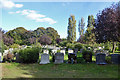
New graves
These graves at Sutton Road cemetery are seem to be new additions. There are two fields at the back for recent graves. I took them from the side so we couldn't see the names on the headstones. You can see the industrial estate and offices behind.
Image: © Julieanne Savage
Taken: 11 Jan 2006
0.18 miles
9
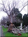
Sutton Road Cemetery
A very gnarled tree overlooks graves, part of its trunk it behind the bench
Image: © Julieanne Savage
Taken: 11 Jan 2006
0.22 miles