IMAGES TAKEN NEAR TO
Southend Road, STANFORD-LE-HOPE, SS17 9EY
Introduction
This page details the photographs taken nearby to Southend Road, SS17 9EY by members of the Geograph project.
The Geograph project started in 2005 with the aim of publishing, organising and preserving representative images for every square kilometre of Great Britain, Ireland and the Isle of Man.

There are currently over 7.5m images from over14,400 individuals and you can help contribute to the project by visiting https://www.geograph.org.uk
Image Map
Images are licensed for reuse under creativecommons.org/licenses/by-sa/2.0
Notes
- Clicking on the map will re-center to the selected point.
- The higher the marker number, the further away the image location is from the centre of the postcode.
Image Listing (13 Images Found)
Images are licensed for reuse under creativecommons.org/licenses/by-sa/2.0
Image
Details
Distance
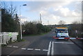
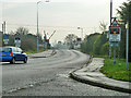
2
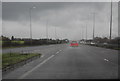
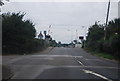
Vange Turn-off
Slip road near Vange giving access to the A176 and the B1464 from the A13.
Image: © Martin Addison
Taken: 25 Apr 2015
0.11 miles
4
View south-east from Langdon Hills Country Park
Near the east end of the far-flung park. The rise in the horizon in the middle of the view is a huge hill of rubbish deposited over the years on the once flat marshland.
Image: © Robin Webster
Taken: 23 Apr 2017
0.14 miles
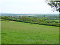
5
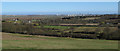
View of Thames Estuary from Langdon Hills Country Park
Looking from a path on the ridge in Langdon Hills Country Park towards the Thames.
In the mid distance is pasture and horses from the nearby livery stables.
In the background you can see the industrial area of the Thames Estuary near Thames Haven and Coryton.
Image: © Roger Jones
Taken: 20 Apr 2013
0.15 miles
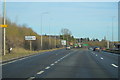
6
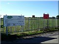
Vange Water Works
This is the entrance to the Vange water treatment works. The dam around the reservoir can be seen immediately behind the fence
Image: © Glyn Baker
Taken: 2 Oct 2005
0.16 miles
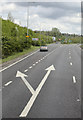
10
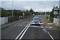
Level Crossing, Vange
The barriers are just descending for a c2c train on the original LTSR route to Southend via Tilbury.
Image: © Robin Webster
Taken: 12 Dec 2013
0.20 miles