IMAGES TAKEN NEAR TO
Rodings Avenue, STANFORD-LE-HOPE, SS17 8DU
Introduction
This page details the photographs taken nearby to Rodings Avenue, SS17 8DU by members of the Geograph project.
The Geograph project started in 2005 with the aim of publishing, organising and preserving representative images for every square kilometre of Great Britain, Ireland and the Isle of Man.

There are currently over 7.5m images from over14,400 individuals and you can help contribute to the project by visiting https://www.geograph.org.uk
Image Map
Images are licensed for reuse under creativecommons.org/licenses/by-sa/2.0
Notes
- Clicking on the map will re-center to the selected point.
- The higher the marker number, the further away the image location is from the centre of the postcode.
Image Listing (8 Images Found)
Images are licensed for reuse under creativecommons.org/licenses/by-sa/2.0
Image
Details
Distance
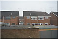
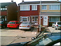
1
Silverdale
A cul-de-sac off Branksome Close, Stanford-le-Hope.
Image: © Trevor Harris
Taken: 7 May 2015
0.18 miles
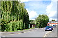
4
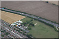
Greenacres Farm
Corringham, adjacent to the A13.
Image: © terry joyce
Taken: 18 Aug 2010
0.22 miles
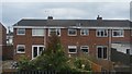
5
Typical Stanford le Hope house.
This is my house at Pugh Place but it's a typical 3 bedroom Stanford le Hope/Corringham home.
Image: © Hazel
Taken: 7 Aug 2005
0.22 miles
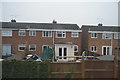
7
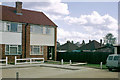
One end of Blythe Road, 1968
A T-shaped dead-end, Blythe Road was a recent infill in the Homesteads area of Stanford-le-Hope in 1968. There was some early confusion about its name - the spelling was Blyth on some documents. Bungalows in Third Avenue, one of the original Homesteads roads, are beyond.
Image: © Robin Webster
Taken: Unknown
0.23 miles