IMAGES TAKEN NEAR TO
Bentalls, BASILDON, SS14 3BU
Introduction
This page details the photographs taken nearby to Bentalls, SS14 3BU by members of the Geograph project.
The Geograph project started in 2005 with the aim of publishing, organising and preserving representative images for every square kilometre of Great Britain, Ireland and the Isle of Man.

There are currently over 7.5m images from over14,400 individuals and you can help contribute to the project by visiting https://www.geograph.org.uk
Image Map
Images are licensed for reuse under creativecommons.org/licenses/by-sa/2.0
Notes
- Clicking on the map will re-center to the selected point.
- The higher the marker number, the further away the image location is from the centre of the postcode.
Image Listing (14 Images Found)
Images are licensed for reuse under creativecommons.org/licenses/by-sa/2.0
Image
Details
Distance
1
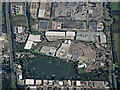
Festival Leisure Park from the air
A "one stop leisure centre" http://www.festivalleisure.co.uk/?AspxAutoDetectCookieSupport=1 in Basildon.
Image: © Thomas Nugent
Taken: 28 Sep 2015
0.09 miles
2
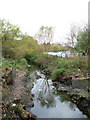
Tributary, River Crouch
This stream is a tributary of the River Crouch. This section first surfaces in a culvert near Butneys and flows through Gloucester Park. It joins the Crouch near Crays Hill.
Image: © terry joyce
Taken: 6 Nov 2011
0.11 miles
3
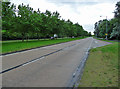
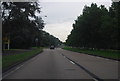
The A1235 at Gloucester Park
The view westwards from south of Basildon's Festival Park.
Image: © John Allan
Taken: 13 Aug 2012
0.14 miles
5
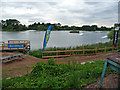
Festival Wakeboard Park
Festival Wakeboard Park is a cable wakeboarding facility on the lake at Festival Leisure Park in Basildon. It boasts a 660 metre 5 pylon cable tow system.
Image: © John Allan
Taken: 13 Aug 2012
0.16 miles

9
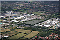
Festival Leisure Park and more
Otherwise known as Bas Vegas is above the lake.
The road running left to right is the A127.
Summerhill Nursery is just below the A127 on the left.
Some of Noak Bridge can be seen in the bottom right of the photo.
Image: © terry joyce
Taken: 18 Aug 2010
0.21 miles