IMAGES TAKEN NEAR TO
Wakering Road, SOUTHEND-ON-SEA, SS1 3RD
Introduction
This page details the photographs taken nearby to Wakering Road, SS1 3RD by members of the Geograph project.
The Geograph project started in 2005 with the aim of publishing, organising and preserving representative images for every square kilometre of Great Britain, Ireland and the Isle of Man.

There are currently over 7.5m images from over14,400 individuals and you can help contribute to the project by visiting https://www.geograph.org.uk
Image Map
Images are licensed for reuse under creativecommons.org/licenses/by-sa/2.0
Notes
- Clicking on the map will re-center to the selected point.
- The higher the marker number, the further away the image location is from the centre of the postcode.
Image Listing (9 Images Found)
Images are licensed for reuse under creativecommons.org/licenses/by-sa/2.0
Image
Details
Distance
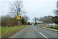
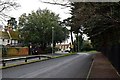
2
Wakering Road past Thorpe Hall School
The sign says that this is the entrance for parent and pupils parking.
Image: © Robin Webster
Taken: 1 Oct 2018
0.12 miles
3
Wakering Road, heading north
Passing Thorpe Hall School.
Image: © Robin Webster
Taken: 6 Apr 2018
0.14 miles
4
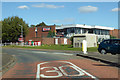
DW Fitness Club, Thorpe Bay
On Wakering Road.
Image: © Robin Webster
Taken: 1 Oct 2018
0.17 miles
5
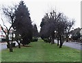
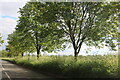
Thorpe Hall Avenue, Thorpe Bay
The grassed over area between the trees is the course of a former Southend Corporation tram route (closed in 1938) that ran down the central reservation of Thorpe Hall Avenue towards Thorpe Bay Corner on the esplanade. Taken looking south.
Image: © David Kemp
Taken: 10 Jan 2006
0.20 miles
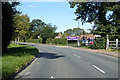
7
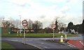
Bournes Green Roundabout, Thorpe Bay
Taken from the corner of Shoebury Road with Wakering Road in the centre right.
Image: © David Kemp
Taken: 11 Jan 2006
0.24 miles
8
Dual Carriageway
Wakering road goes dual for a very short distance through the Z-bend south of the Rose Inn
Image: © John Myers
Taken: 22 Jan 2015
0.24 miles
9
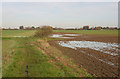
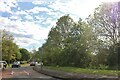
Waterlogged field north of Bournes Green
Seen from the footpath from Bournes Green to Silchester Corner. This is not the image of Southend that many have.
Image: © David Kemp
Taken: 24 Nov 2014
0.25 miles