IMAGES TAKEN NEAR TO
Archers Fields, BASILDON, SS13 1DN
Introduction
This page details the photographs taken nearby to Archers Fields, SS13 1DN by members of the Geograph project.
The Geograph project started in 2005 with the aim of publishing, organising and preserving representative images for every square kilometre of Great Britain, Ireland and the Isle of Man.

There are currently over 7.5m images from over14,400 individuals and you can help contribute to the project by visiting https://www.geograph.org.uk
Image Map
Images are licensed for reuse under creativecommons.org/licenses/by-sa/2.0
Notes
- Clicking on the map will re-center to the selected point.
- The higher the marker number, the further away the image location is from the centre of the postcode.
Image Listing (5 Images Found)
Images are licensed for reuse under creativecommons.org/licenses/by-sa/2.0
Image
Details
Distance
1
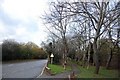
Footpath by Burnt Mills Road, Nevendon
Hidden by trees, Burnt Mills Industrial Estate is to the right, while a residential area is to the left of the road.
Image: © Trevor Harris
Taken: 14 Nov 2009
0.15 miles
2
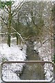
A Nevedon Stream
This stream marks the northern boundary of Image nature reserve one of the only fragments of ancient woodland left in the urban area of Basildon it is classified as a local nature reserve see
http://www.basildon.gov.uk/index.aspx?articleid=2408 for more information.
Image: © Glyn Baker
Taken: 9 Jan 2010
0.15 miles
3
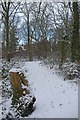
Stumped
Image is one of the only fragments of ancient woodland left in the urban area of Basildon it is classified as a local nature reserve see
http://www.basildon.gov.uk/index.aspx?articleid=2408 for more information. There are well made paths like this one throughout the wood.
Image: © Glyn Baker
Taken: 9 Jan 2010
0.18 miles
4
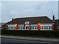
ITEC offices on Burnt Mills Road
ITEC Learning Technologies offices in Basildon.
Image: © John Allan
Taken: 20 Sep 2011
0.20 miles
5
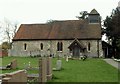
St. Peter; the parish church of old Nevendon
This small church is mainly 13th to 15th century and is located in Basildon new town. Nevendon is one of a handful of villages that was swallowed up by the new town and it is not easy to imagine what the original village looked like. An 18th century map shows that the village did indeed surround this church but modern maps now show Nevendon a good distance east of this church. Judging by the neat and tidy graveyard it is still a church that is loved and cared for, which is good to know.
Image: © Robert Edwards
Taken: 9 Apr 2008
0.22 miles