IMAGES TAKEN NEAR TO
Stilemans, WICKFORD, SS11 8BD
Introduction
This page details the photographs taken nearby to Stilemans, SS11 8BD by members of the Geograph project.
The Geograph project started in 2005 with the aim of publishing, organising and preserving representative images for every square kilometre of Great Britain, Ireland and the Isle of Man.

There are currently over 7.5m images from over14,400 individuals and you can help contribute to the project by visiting https://www.geograph.org.uk
Image Map
Images are licensed for reuse under creativecommons.org/licenses/by-sa/2.0
Notes
- Clicking on the map will re-center to the selected point.
- The higher the marker number, the further away the image location is from the centre of the postcode.
Image Listing (37 Images Found)
Images are licensed for reuse under creativecommons.org/licenses/by-sa/2.0
Image
Details
Distance
1
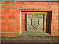
Bridge over the River Crouch
This plaque is on the bridge that spans the River Crouch in Lower Southend Road in Wickford Town Centre.
Image: © terry joyce
Taken: 3 Jan 2010
0.06 miles
2
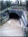
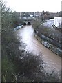
River Crouch in spate
After several days of rain, a swollen and very muddy River Crouch, narrows under the railway in Wickford.
Image: © John Myers
Taken: 25 Feb 2007
0.06 miles
3
Bridge over the River Crouch
This is the bridge that spans the River Crouch in Lower Southend Road in Wickford Town Centre. The plaque indicates that it was built in 1915.
See Image
Image: © terry joyce
Taken: 3 Jan 2010
0.07 miles
4
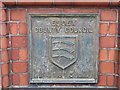
Old Bridge Marker by Lower Southend Road, Wickford
Bridge Marker by the UC road, in parish of Wickford (Basildon District), on bridge over River Crouch, Lower Southend Road, Northeast side bridge parapet.
Inscription reads:-
ESSEX
COUNTY COUNCIL
{coat of arms}
1915
Surveyed
Milestone Society National ID: EX_WICK01br
Image: © Milestone Society
Taken: Unknown
0.08 miles
7
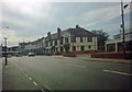
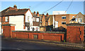
Swans Pub
Swans pub on the corner of Swan Lane and The Broadway, Wickford, Essex.
Image: © Fast Track images
Taken: 21 Aug 2011
0.11 miles
8
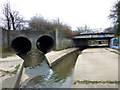
The Confluence
The large pipes on the left are Nevendon Brook joining the River Crouch in Wickford. The pipes (culvert) flow under the roundabout on the A132. The bridge is the access road to the supermarket and car park.
The second bridge is the A129 London Road.
Image: © terry joyce
Taken: 22 Feb 2013
0.13 miles
9
Upstream from the footbridge
River Crouch in Wickford.
Image: © John Myers
Taken: 25 Feb 2007
0.13 miles
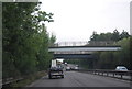
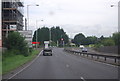
10
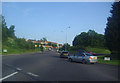
Roundabout on Golden Jubilee Way, Wickford
Image: © David Howard
Taken: 20 Jun 2012
0.13 miles