IMAGES TAKEN NEAR TO
Dene House Road, SEAHAM, SR7 7BQ
Introduction
This page details the photographs taken nearby to Dene House Road, SR7 7BQ by members of the Geograph project.
The Geograph project started in 2005 with the aim of publishing, organising and preserving representative images for every square kilometre of Great Britain, Ireland and the Isle of Man.

There are currently over 7.5m images from over14,400 individuals and you can help contribute to the project by visiting https://www.geograph.org.uk
Image Map
Images are licensed for reuse under creativecommons.org/licenses/by-sa/2.0
Notes
- Clicking on the map will re-center to the selected point.
- The higher the marker number, the further away the image location is from the centre of the postcode.
Image Listing (24 Images Found)
Images are licensed for reuse under creativecommons.org/licenses/by-sa/2.0
Image
Details
Distance
2
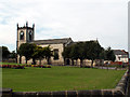
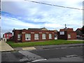
The Parish Of St John Church
A nice church in the heart of Seaham
Image: © Colin Keightley
Taken: 22 Aug 2005
0.14 miles
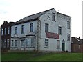
3
Rock House, Tempest Road, Seaham
Built in the mid-19th century, Rock House became a community centre in 1931. It doesn't appear to be listed and the site was recently offered for sale at £160,000. The house now appears to be in very poor condition.
Image: © John Lucas
Taken: 8 Jul 2014
0.15 miles
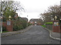
4
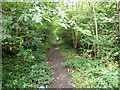
On the route of the Seaham railway incline
The incline carried coal wagons down to Seaham Harbour. It was 'self-acting' in that wagons laden with coal would run down the incline, pulling empty ones to the top by means of ropes and pulleys. Very sad to see it as it is now, just an overgrown footpath.
Image: © John Lucas
Taken: 13 Aug 2012
0.17 miles
5
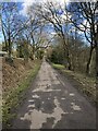
Dismantled railway line, Seaham
The railway was originally built to connect Seaham Colliery, situated to the west of the town, with the Harbour for the east coast coal trade.
Image: © Andrew Curtis
Taken: 9 Oct 2009
0.17 miles
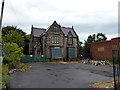
6
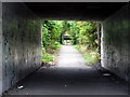
Former inclined railway to Seaham docks
Looking down the former incline that ran from Seaham colliery to Seaham docks. Now a foot / cycle route from the railway station to the town centre and the Durham coast.
Image: © David Robinson
Taken: 7 Mar 2023
0.17 miles
8
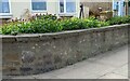
Seaham, North Road
Wider view of located benchmark on perimeter wall - 1914 map says 68ft above sea level.
Image: © Mel Towler
Taken: 15 May 2021
0.19 miles
9
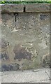
Seaham, North Road
Benchmark on perimeter wall of house, 2 residences to left of Masonic Hall
Image: © Mel Towler
Taken: 15 May 2021
0.19 miles