IMAGES TAKEN NEAR TO
Tintagel Drive, SEAHAM, SR7 7AL
Introduction
This page details the photographs taken nearby to Tintagel Drive, SR7 7AL by members of the Geograph project.
The Geograph project started in 2005 with the aim of publishing, organising and preserving representative images for every square kilometre of Great Britain, Ireland and the Isle of Man.

There are currently over 7.5m images from over14,400 individuals and you can help contribute to the project by visiting https://www.geograph.org.uk
Image Map
Images are licensed for reuse under creativecommons.org/licenses/by-sa/2.0
Notes
- Clicking on the map will re-center to the selected point.
- The higher the marker number, the further away the image location is from the centre of the postcode.
Image Listing (22 Images Found)
Images are licensed for reuse under creativecommons.org/licenses/by-sa/2.0
Image
Details
Distance
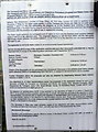
2
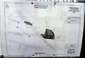
Order to close Seaham Level Crossing Footpath - plan of area affected
Image: © John Lucas
Taken: 13 Aug 2012
0.21 miles
3
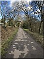
Former inclined railway to Seaham docks
Looking down the former incline that ran from Seaham colliery to Seaham docks. Now a foot / cycle route from the railway station to the town centre and the Durham coast.
Image: © David Robinson
Taken: 7 Mar 2023
0.21 miles
4
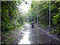
A wet morning at Seaham
Footpath on the route of the old self-acting coal railway.
Image: © John Lucas
Taken: 8 Jul 2014
0.21 miles
5
Notice of an application for an Order to close Seaham Level Crossing Footpath
Image: © John Lucas
Taken: 13 Aug 2012
0.21 miles
6
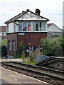
Seaham Signal Box
The box was retained specifically to control the adjacent foot crossing but in July 2012, Network Rail applied for an Order to close the crossing and make alternative arrangements (using an underpass) for crossing the railway. If and when the application is allowed, the box will be closed.
See also Image and Image
The foot crossing was closed and 'box demolished by 2014. See Image
Image: © John Lucas
Taken: 13 Aug 2012
0.21 miles
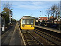
7
Empty? coal wagons being hauled through Seaham station
Image: © John Lucas
Taken: 8 Jul 2014
0.22 miles
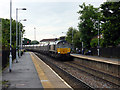
8
On Seaham Railway Station
Northern Rail train bound for Hexham via Newcastle.
Image: © JThomas
Taken: 10 Nov 2012
0.22 miles
9
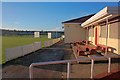
Seaham Harbour Cricket Club
"Establish in 1868 by the Londonderry Coal Company for their staff, the community of Seaham Harbour and in 1931 the management and miners of Vane Tempest Colliery."
According to a blue plaque on the wall.
Image: © Mick Garratt
Taken: 7 Nov 2013
0.22 miles
10
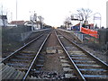
Seaham railway station, County Durham
Opened in 1855 by the Londonderry Seaham and Sunderland Railway, later part of the North Eastern Railway, on what is today the line from Stockton to Sunderland. The station was known as 'Seaham Colliery' until 1925.
View north west from the level crossing towards Hall Dene and Sunderland. The level crossing was removed a few years later.
Image: © Nigel Thompson
Taken: 14 Jan 2011
0.22 miles