IMAGES TAKEN NEAR TO
Thomas Street South, SUNDERLAND, SR5 2BB
Introduction
This page details the photographs taken nearby to Thomas Street South, SR5 2BB by members of the Geograph project.
The Geograph project started in 2005 with the aim of publishing, organising and preserving representative images for every square kilometre of Great Britain, Ireland and the Isle of Man.

There are currently over 7.5m images from over14,400 individuals and you can help contribute to the project by visiting https://www.geograph.org.uk
Image Map
Images are licensed for reuse under creativecommons.org/licenses/by-sa/2.0
Notes
- Clicking on the map will re-center to the selected point.
- The higher the marker number, the further away the image location is from the centre of the postcode.
Image Listing (35 Images Found)
Images are licensed for reuse under creativecommons.org/licenses/by-sa/2.0
Image
Details
Distance
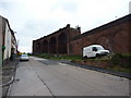
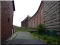
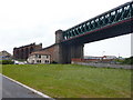
2
Railway viaduct, Queen Alexandra Bridge
Formerly the railway approach to Queen Alexandra Bridge, this viaduct now stands in rather forlorn isolation.
Image: © Antony Dixon
Taken: 13 Jan 2012
0.03 miles
3
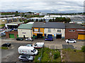
Commercial premises at Low Southwick
Looking down from the north end of Queen Alexandra Bridge
Image: © Oliver Dixon
Taken: 19 Jun 2015
0.03 miles
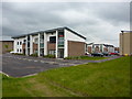
5
Backstreet, Sunderland
Back street between The Times Inn and Queen Alexandra Bridge
Image: © Alexander P Kapp
Taken: 26 May 2011
0.06 miles
6
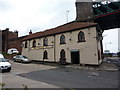
The Times Inn, Wear Street, Sunderland
Image: © Alexander P Kapp
Taken: 26 May 2011
0.06 miles
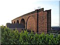
7
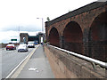
Northern end of the Queen Alexandra Bridge
The Queen Alexandra Bridge over the River Wear was built in 1909 and was originally a double-decker bridge with a railway on the top (long since discontinued and dismantled). In the foreground are the brick arches of the former railway.
The bridge is a Grade II listed structure and its lattice girder construction is the heaviest ever built. Cycle- and foot-ways pass under the arches seen in the distance to span the river on the outside of the girders.
Image: © Oliver Dixon
Taken: 19 Jun 2015
0.06 miles
8
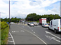
Traffic at the northern end of Queen Alexandra Bridge
Streams of traffic waiting at lights to enter the gyratory system.
Image: © Oliver Dixon
Taken: 19 Jun 2015
0.07 miles
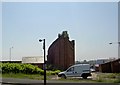
9
Queen Alexandra Bridge, Sunderland
The red sandstone structure in the background is all of what remains of the viaduct which carried coal from mines north of the river. The building is The Times Inn
Image: © Alexander P Kapp
Taken: 26 May 2011
0.10 miles
10
Offices on the southside of Crown Road, Sunderland
Image: © Alexander P Kapp
Taken: 26 May 2011
0.11 miles