IMAGES TAKEN NEAR TO
Lumley Street, SUNDERLAND, SR4 7DZ

Introduction

This page details the photographs taken nearby to Lumley Street, SR4 7DZ by members of the Geograph project.

The Geograph project started in 2005 with the aim of publishing, organising and preserving representative images for every square kilometre of Great Britain, Ireland and the Isle of Man.

There are currently over 7.5m images from over14,400 individuals and you can help contribute to the project by visiting https://www.geograph.org.uk

Image Map


Images are licensed for reuse under creativecommons.org/licenses/by-sa/2.0
Notes
  • Clicking on the map will re-center to the selected point.
  • The higher the marker number, the further away the image location is from the centre of the postcode.

Image Listing (34 Images Found)

Images are licensed for reuse under creativecommons.org/licenses/by-sa/2.0
  • ...
Image
Details
Distance
1
Chester Road
Main road (A183) near the City centre.
Image: © Oliver Dixon Taken: 15 Nov 2016
0.10 miles
2
Looking west along Chester Road
Chester Road is one of the main routes west out from Sunderland city centre. This part has a lot of local shops.
Image: © Robert Graham Taken: 17 Oct 2016
0.10 miles
3
Chester Road, Sunderland
Image: © Iain Lees Taken: 18 Sep 2010
0.10 miles
4
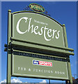
Chesters pub
Image: © JThomas Taken: 28 May 2015
0.11 miles
5
Sign for Chesters pub
Image: © JThomas Taken: 28 May 2015
0.13 miles
6
The Back Lane on Eldon Street, Sunderland
The Lane made me think of Coronation St
Image: © Iain Lees Taken: 18 Sep 2010
0.14 miles
7
High Barnes Terrace, Sunderland
Typical of a whole series of terraced streets south of Chester Road, lined with the single storey terraced houses known as Sunderland Cottages. They are a type almost unique to Sunderland widely built from the mid C19 right up until 1930's.
Image: © Robert Graham Taken: 17 Oct 2016
0.17 miles
8
Shops along Chester Road, Sunderland
Looking west near the junction with Cleveland Road.
Image: © Robert Graham Taken: 17 Oct 2016
0.17 miles
9
Millfield Metro station, Tyne & Wear
Opened in 1853 by the York Newcastle & Berwick Railway, soon to be part of the North Eastern Railway, on the line from Durham to Sunderland. This station closed to passengers in 1890 when it was replaced by one beyond the bridge. This in turn was closed in 1955. A Metro station was opened on the site of the original station in 2002. View north west towards Pallion and Durham, although the Metro only ran as far as South Hylton at the time this image was taken. For more information, see http://www.disused-stations.org.uk/m/millfield_first/index.shtml
Image: © Nigel Thompson Taken: 24 Mar 2012
0.18 miles
10
Shops on Chester Road (A183)
Image: © JThomas Taken: 28 May 2015
0.18 miles
  • ...