IMAGES TAKEN NEAR TO
Bowtrees, SUNDERLAND, SR2 7TL
Introduction
This page details the photographs taken nearby to Bowtrees, SR2 7TL by members of the Geograph project.
The Geograph project started in 2005 with the aim of publishing, organising and preserving representative images for every square kilometre of Great Britain, Ireland and the Isle of Man.

There are currently over 7.5m images from over14,400 individuals and you can help contribute to the project by visiting https://www.geograph.org.uk
Image Map
Images are licensed for reuse under creativecommons.org/licenses/by-sa/2.0
Notes
- Clicking on the map will re-center to the selected point.
- The higher the marker number, the further away the image location is from the centre of the postcode.
Image Listing (35 Images Found)
Images are licensed for reuse under creativecommons.org/licenses/by-sa/2.0
Image
Details
Distance
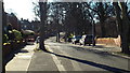
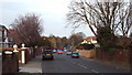
3
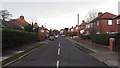
The Glen, Sunderland
The Glen is a residential cul-de-sac in Sunderland.
Image: © Malc McDonald
Taken: 8 Mar 2014
0.09 miles
5
Glen Path, Sunderland
Glen Path is a residential road in Sunderland. The road runs along the edge of Backhouse Park.
Image: © Malc McDonald
Taken: 7 Mar 2014
0.11 miles
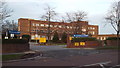
7
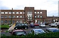
Beecholm Court retirement flats, Sunderland
Beecholm Court is a development of retirement flats in Sunderland.
Image: © Malc McDonald
Taken: 7 Mar 2014
0.11 miles
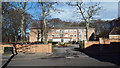
8
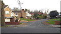
Backhouse Park, Sunderland
An entrance to Backhouse Park in Sunderland.
Image: © Malc McDonald
Taken: 7 Mar 2014
0.12 miles
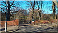
10
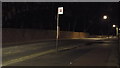
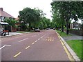
Bus stop on The Cedars, Sunderland
The Cedars, a suburban road in Sunderland, at night. Behind the wall on the opposite side of the road is a park.
Image: © Malc McDonald
Taken: 19 Apr 2014
0.13 miles