IMAGES TAKEN NEAR TO
SUNDERLAND, SR1 2LA
Introduction
This page details the photographs taken nearby to SR1 2LA by members of the Geograph project.
The Geograph project started in 2005 with the aim of publishing, organising and preserving representative images for every square kilometre of Great Britain, Ireland and the Isle of Man.

There are currently over 7.5m images from over14,400 individuals and you can help contribute to the project by visiting https://www.geograph.org.uk
Image Map
Images are licensed for reuse under creativecommons.org/licenses/by-sa/2.0
Notes
- Clicking on the map will re-center to the selected point.
- The higher the marker number, the further away the image location is from the centre of the postcode.
Image Listing (131 Images Found)
Images are licensed for reuse under creativecommons.org/licenses/by-sa/2.0
Image
Details
Distance
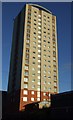
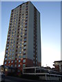
3
Fish Quay and River View apartments, south side of the River Wear
Lumley, Londonderry and Lambton Towers stand behind.
Image: © Andrew Curtis
Taken: 10 Dec 2010
0.03 miles
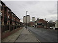
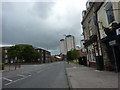
7
England Coast Path at High Street East, Sunderland
At this point, next to a not very elegant piece of concrete statuary, the England Coast Path leaves the pavement along High Street East and descends steps towards Low Street and the Riverside.
Image: © Oliver Dixon
Taken: 23 Feb 2016
0.05 miles
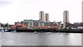
8
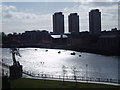
Looking over the River Wear from Monkwearmouth to Sunderland, 17th April 2006
Image: © Martin Routledge
Taken: 17 Apr 2006
0.05 miles
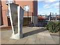
9
Sunderland Riverside at the Ferry Landing
This plaque by the south shore of the Wear Estuary (part of the Old Sunderland Heritage Trail) records that this is the site of the Ferry Landing which was in use as a crossing as early as the 7th century. The fare was one old halfpenny from the 18th century right up until its closure in 1957.
Image: © Oliver Dixon
Taken: 23 Feb 2016
0.06 miles
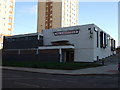
10

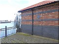
Sunderland Fish Quay
Sunderland fish quay area
Image: © Jim Bryce
Taken: 11 Oct 2019
0.06 miles