IMAGES TAKEN NEAR TO
Havelock Street, SUNDERLAND, SR1 2BD
Introduction
This page details the photographs taken nearby to Havelock Street, SR1 2BD by members of the Geograph project.
The Geograph project started in 2005 with the aim of publishing, organising and preserving representative images for every square kilometre of Great Britain, Ireland and the Isle of Man.

There are currently over 7.5m images from over14,400 individuals and you can help contribute to the project by visiting https://www.geograph.org.uk
Image Map
Images are licensed for reuse under creativecommons.org/licenses/by-sa/2.0
Notes
- Clicking on the map will re-center to the selected point.
- The higher the marker number, the further away the image location is from the centre of the postcode.
Image Listing (120 Images Found)
Images are licensed for reuse under creativecommons.org/licenses/by-sa/2.0
Image
Details
Distance
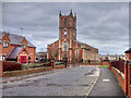
2
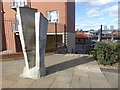
England Coast Path at High Street East, Sunderland
At this point, next to a not very elegant piece of concrete statuary, the England Coast Path leaves the pavement along High Street East and descends steps towards Low Street and the Riverside.
Image: © Oliver Dixon
Taken: 23 Feb 2016
0.06 miles

6
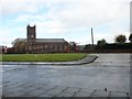
Church of the Holy Trinity, Sunderland
Built in the early C18 as the original parish church for the town in a very modern style for the time. This area in the east was the original town centre.
Image: © Robert Graham
Taken: 17 Oct 2016
0.08 miles
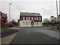
7
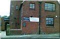
The Watermans public house, Sunderland
Image: © Alex McGregor
Taken: 15 Jun 2011
0.09 miles
8
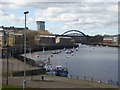
Noble's Quay, Sunderland
View from High Street East. The yellow building is Wylam Wharf Image Upstream can be seen the steel arches of the Wearmouth Road and Rail Bridges Image
Image: © Oliver Dixon
Taken: 23 Feb 2016
0.09 miles
9

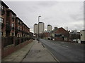
The dreaming towers of Sunderland
In the foreground is Holy Trinity Church, a listed building dating from in 1718-19. In the 18th century, the church was at the heart of the community centred on the port. Beyond are three modern apartment blocks.
Image: © Oliver Dixon
Taken: 23 Feb 2016
0.09 miles
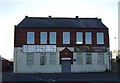
10
Church of Holy Trinity
Holy Trinity Church was opened in 1719 as the church for the newly created Parish of Sunderland and is one of the oldest buildings in the East End of Sunderland. Once at the heart of the community centred on the port, the church was closed in 1988 because of a dwindling congregation and the need for expensive repairs (http://twsitelines.info/SMR/4421 Tyne and Wear HER(4421)). It is now in the care of the Churches Conservation Trust.
The church is a Grade I listed building (English Heritage List Entry Number: 1208056 http://www.heritagegateway.org.uk/Gateway/Results_Single.aspx?uid=1208056&resourceID=5 Heritage Gateway).
See also See Image]
Image: © David Dixon
Taken: 24 Mar 2016
0.09 miles