IMAGES TAKEN NEAR TO
Humber Lane, TIDWORTH, SP9 7AW
Introduction
This page details the photographs taken nearby to Humber Lane, SP9 7AW by members of the Geograph project.
The Geograph project started in 2005 with the aim of publishing, organising and preserving representative images for every square kilometre of Great Britain, Ireland and the Isle of Man.

There are currently over 7.5m images from over14,400 individuals and you can help contribute to the project by visiting https://www.geograph.org.uk
Image Map
Images are licensed for reuse under creativecommons.org/licenses/by-sa/2.0
Notes
- Clicking on the map will re-center to the selected point.
- The higher the marker number, the further away the image location is from the centre of the postcode.
Image Listing (8 Images Found)
Images are licensed for reuse under creativecommons.org/licenses/by-sa/2.0
Image
Details
Distance
2
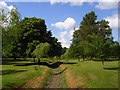
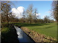
Tidworth Park
The grounds of Tidworth House. Looking along the dried up course of the River Bourne.
Image: © Andrew Smith
Taken: 20 May 2007
0.17 miles
3
Tidworth - Tidworth Park
This public park used to be part of the grounds of Tedworth House.
Image: © Chris Talbot
Taken: 24 Jan 2009
0.17 miles
4
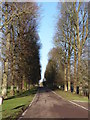
Tidworth - Tidworth Park
Fine avenue of trees in Tidworth Park.
Image: © Chris Talbot
Taken: 24 Jan 2009
0.17 miles
5
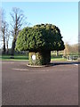
Tidworth - Roundabout
This bush has been shaped into a roundabout.
Image: © Chris Talbot
Taken: 24 Jan 2009
0.17 miles
6

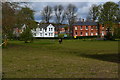
Tidworth House
In parkland with fine trees. The army bought the estate in 1897.
Image: © Andrew Smith
Taken: 20 May 2007
0.20 miles
7
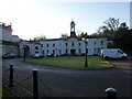
Tidworth - Officers Mess
This used to be part of Tedworth House but is now the Officers Mess.
Image: © Chris Talbot
Taken: 24 Jan 2009
0.20 miles
8

Tedworth House, Tidworth, Wiltshire
Image: © Andrew Mathewson
Taken: 5 Mar 2010
0.20 miles