IMAGES TAKEN NEAR TO
GILLINGHAM, SP8 5NS
Introduction
This page details the photographs taken nearby to SP8 5NS by members of the Geograph project.
The Geograph project started in 2005 with the aim of publishing, organising and preserving representative images for every square kilometre of Great Britain, Ireland and the Isle of Man.

There are currently over 7.5m images from over14,400 individuals and you can help contribute to the project by visiting https://www.geograph.org.uk
Image Map
Images are licensed for reuse under creativecommons.org/licenses/by-sa/2.0
Notes
- Clicking on the map will re-center to the selected point.
- The higher the marker number, the further away the image location is from the centre of the postcode.
Image Listing (9 Images Found)
Images are licensed for reuse under creativecommons.org/licenses/by-sa/2.0
Image
Details
Distance
1
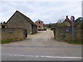
Wyke Farm
On the outskirts of Gillingham; note the octagonal granary on staddle stones: http://www.imagesofengland.org.uk/Details/Default.aspx?id=102995&mode=adv
Image: © Mike Faherty
Taken: 30 Mar 2013
0.08 miles
2

Gillingham: signpost at Slaughtergate
This finger-post has fairly modern replacement fingers - with adhesive rather than the old fashioned screwed in lettering - but retains the original finial, giving location and six-figure grid reference. The finger pointing towards us has amended wording from the original, now that Wavering Lane has been closed to through traffic with the two segments suffixed West and East.
For a close-up of the finial, see Image
Image: © Chris Downer
Taken: 24 Oct 2010
0.10 miles
3

Gillingham: detail of Slaughtergate signpost
A close-up of the finial on Image, which gives the location and six-figure grid reference.
Image: © Chris Downer
Taken: 24 Oct 2010
0.10 miles
4

Gillingham: finger-post at Wyke
This signpost retains the original finial, giving location and six-figure grid reference.
Image: © Chris Downer
Taken: 8 Aug 2009
0.11 miles
5

Gillingham: detail of Wyke finger-post finial
A close-up of the finial at the top of the Image which gives the location and six-digit grid reference.
Image: © Chris Downer
Taken: 24 Oct 2010
0.12 miles
7
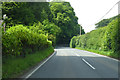
B3081 heading north-west
Towards the A303 and some way beyond, Bruton.
Image: © Robin Webster
Taken: 10 Jun 2018
0.19 miles
9
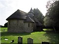
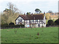
St George's Chapel
A thatched roof chapel.
http://www.achurchnearyou.com/langham/read-about-the-history-of-this-chapel-.html
Image: © Chris McAuley
Taken: 21 Aug 2013
0.24 miles