IMAGES TAKEN NEAR TO
Bourne Way, GILLINGHAM, SP8 4PF
Introduction
This page details the photographs taken nearby to Bourne Way, SP8 4PF by members of the Geograph project.
The Geograph project started in 2005 with the aim of publishing, organising and preserving representative images for every square kilometre of Great Britain, Ireland and the Isle of Man.

There are currently over 7.5m images from over14,400 individuals and you can help contribute to the project by visiting https://www.geograph.org.uk
Image Map
Images are licensed for reuse under creativecommons.org/licenses/by-sa/2.0
Notes
- Clicking on the map will re-center to the selected point.
- The higher the marker number, the further away the image location is from the centre of the postcode.
Image Listing (22 Images Found)
Images are licensed for reuse under creativecommons.org/licenses/by-sa/2.0
Image
Details
Distance
1
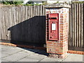
Gillingham: a postbox catches the sunlight
A much more useful view of Image, in terms of making out the George VI cipher and the brickwork of the pillar, which looks a little damaged in one corner.
Image: © Chris Downer
Taken: 14 Oct 2012
0.10 miles
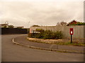
2
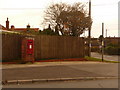
Gillingham: postbox № SP8 59, Fairey Crescent
This George VI-reign postbox is set into a brick pillar on the corner of Fairey Crescent and the B3092 which, seemingly, does not have a road name. It is emptied finally at 5:45pm on weekdays and at 11:45am on Saturdays.
Image: © Chris Downer
Taken: 18 Oct 2009
0.10 miles
3
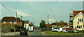
B3092 at Lodbourne
At the junction with Lodbourne Terrace (right), a short cul-de-sac.
Image: © Derek Harper
Taken: 7 May 2024
0.13 miles
4
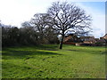
Ancient Trees!
These trees are on a small green open space along Gyllas Way at Peacemarsh, Gillingham. To the left are the remains of an Ancient Woodland hedgerow.
Image: © Clive Warneford
Taken: 6 Feb 2008
0.13 miles
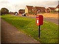
5
Gillingham: postbox № SP8 123, Wessex Way
This postbox is emptied finally at 5:45pm on weekdays and at 11:45am on Saturdays. Further to the left are two drop boxes (see below).
Image: © Chris Downer
Taken: 18 Oct 2009
0.15 miles
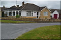
6
![Gillingham houses [25]](https://s2.geograph.org.uk/geophotos/06/08/58/6085850_ef1d9c48_120x120.jpg)
Gillingham houses [25]
Lodborne Farmhouse is late 18th century and is listed, grade II, with details at: https://historicengland.org.uk/listing/the-list/list-entry/1110298 The house is located in the middle of an estate of very ordinary bungalows, presumably built on the farmland. The property is shown as Lodborne Resource Centre under abortion clinics, and a planning application was approved in 2016 to change the building from multiple occupation to one house offering bed and breakfast accommodation.
Image: © Michael Dibb
Taken: 14 Feb 2019
0.15 miles
7
![Gillingham houses [26]](https://s1.geograph.org.uk/geophotos/06/08/58/6085853_a97045b1_120x120.jpg)
Gillingham houses [26]
Lodborne Farmhouse within its enclosing hedge, is late 18th century and is listed, grade II, with details at: https://historicengland.org.uk/listing/the-list/list-entry/1110298 The house is located in the middle of an estate of very ordinary bungalows, presumably built on the farmland. The property is shown as Lodborne Resource Centre under abortion clinics, and a planning application was approved in 2016 to change the building from multiple occupation to one house offering bed and breakfast accommodation.
Image: © Michael Dibb
Taken: 14 Feb 2019
0.15 miles
8
Gillingham: postbox № SP8 20, Gyllas Way
This postbox stands on the corner of Highgrove, down which it faces, and is emptied finally at 5:45pm on weekdays and at 11:45am on Saturdays.
Image: © Chris Downer
Taken: 18 Oct 2009
0.18 miles
10
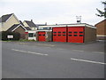
Gillingham Fire Station
A view looking to the southwest across the B3092 towards the Fire Station at Gillingham.
Image: © Phil Williams
Taken: 13 Aug 2006
0.20 miles