IMAGES TAKEN NEAR TO
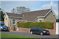
Wyke Street, GILLINGHAM, SP8 4NA
Introduction
This page details the photographs taken nearby to Wyke Street, SP8 4NA by members of the Geograph project.
The Geograph project started in 2005 with the aim of publishing, organising and preserving representative images for every square kilometre of Great Britain, Ireland and the Isle of Man.

There are currently over 7.5m images from over14,400 individuals and you can help contribute to the project by visiting https://www.geograph.org.uk
Image Map
Images are licensed for reuse under creativecommons.org/licenses/by-sa/2.0
Notes
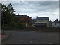
- Clicking on the map will re-center to the selected point.
- The higher the marker number, the further away the image location is from the centre of the postcode.
Image Listing (291 Images Found)
Images are licensed for reuse under creativecommons.org/licenses/by-sa/2.0
Image
Details
Distance
1
![Gillingham houses [32]](https://s3.geograph.org.uk/geophotos/06/08/66/6086635_9e86c3bc_120x120.jpg)
Gillingham houses [32]
Little Chantry is probably early 18th century and contains some original internal features. Listed, grade II, with details at: https://historicengland.org.uk/listing/the-list/list-entry/1324576
Image: © Michael Dibb
Taken: 14 Feb 2019
0.01 miles
2
![Gillingham houses [33]](https://s1.geograph.org.uk/geophotos/06/08/66/6086637_f5ff2eeb_120x120.jpg)
Gillingham houses [33]
Folly's End is probably early 18th century. Listed, grade II, with details at: https://historicengland.org.uk/listing/the-list/list-entry/1110310
Image: © Michael Dibb
Taken: 14 Feb 2019
0.02 miles
3
Catholic Church of St Benedict
On Cemetery Road.
Image: © John M
Taken: 15 Sep 2014
0.02 miles
4
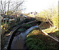
Bend in the River Stour, Gillingham
Viewed from Le Neubourg Way looking towards Wyke Street.
Image: © Jaggery
Taken: 13 Dec 2014
0.02 miles
5
West along Wyke Street, Gillingham
Viewed across Le Neubourg Way. Wyke Street leads to Wyke Road, the way to Wincanton in South Somerset.
Image: © Jaggery
Taken: 13 Dec 2014
0.03 miles
6
![Gillingham houses [31]](https://s2.geograph.org.uk/geophotos/06/08/66/6086634_b800d013_120x120.jpg)
Gillingham houses [31]
Originally one house but now two houses named River Gate (seen here) and Plank House (see Image). Possibly 17th century origins but mainly 18th century. Listed, grade II, with details at: https://historicengland.org.uk/listing/the-list/list-entry/1151937
Image: © Michael Dibb
Taken: 14 Feb 2019
0.03 miles
7
![Gillingham houses [30]](https://s0.geograph.org.uk/geophotos/06/08/66/6086632_b7aadb3d_120x120.jpg)
Gillingham houses [30]
Originally one house but now two houses named Plank House (seen here) and River Gate (see Image). Possibly 17th century origins but mainly 18th century. Listed, grade II, with details at: https://historicengland.org.uk/listing/the-list/list-entry/1151937
Image: © Michael Dibb
Taken: 14 Feb 2019
0.03 miles
8
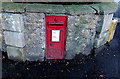
King George V postbox on a corner in Gillingham
In the wall here http://www.geograph.org.uk/photo/4290534 on the corner of Common Mead Lane and Wyke Road.
Image: © Jaggery
Taken: 13 Dec 2014
0.04 miles
9
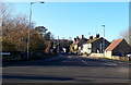
Road junction in centre of Gillingham
Traffic lights control the junction of B3081 and B3092. The buildings ahead are on The Square, which was the former route of the roads through the town.
Image: © David Smith
Taken: 22 Jun 2013
0.04 miles
10
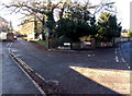
Common Mead Lane, Gillingham
To the right of the blue sign indicating no through road, text on a sign shows
VEHICULAR ACCESS TO COMMON MEAD LANE VIA BROAD ROBIN, but does not state where Broad Robin is (accessed via Wyke Road on the right). The postbox http://www.geograph.org.uk/photo/4290535 in the wall on the right is unusually large for this area outside the town centre.
Image: © Jaggery
Taken: 13 Dec 2014
0.04 miles