IMAGES TAKEN NEAR TO
Hardings Lane, GILLINGHAM, SP8 4HU
Introduction
This page details the photographs taken nearby to Hardings Lane, SP8 4HU by members of the Geograph project.
The Geograph project started in 2005 with the aim of publishing, organising and preserving representative images for every square kilometre of Great Britain, Ireland and the Isle of Man.

There are currently over 7.5m images from over14,400 individuals and you can help contribute to the project by visiting https://www.geograph.org.uk
Image Map
Images are licensed for reuse under creativecommons.org/licenses/by-sa/2.0
Notes
- Clicking on the map will re-center to the selected point.
- The higher the marker number, the further away the image location is from the centre of the postcode.
Image Listing (128 Images Found)
Images are licensed for reuse under creativecommons.org/licenses/by-sa/2.0
Image
Details
Distance
1
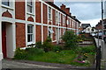
Terrace of houses in Newbury, Gillingham
Image: © David Martin
Taken: 31 May 2019
0.06 miles
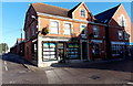
2
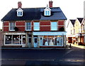
Cupids Corner, Newbury, Gillingham
Viewed across the street named Newbury.
Cupids Corner bridal design shop on the right is next door to Eden Beauty Salon.
Image: © Jaggery
Taken: 13 Dec 2014
0.08 miles
3
Octopus in Gillingham
The corner office is Octopus Personnel, located in Newbury Court in Gillingham town centre.
Image: © Jaggery
Taken: 13 Dec 2014
0.09 miles
4
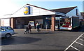
Lidl entrance, Gillingham
Lidl's Gillingham Dorset supermarket is alongside School Lane on the north side of High Street and Newbury. A Gillingham Mere and Shaftesbury Lions Club tractor and trailer are parked on the right.
Image: © Jaggery
Taken: 13 Dec 2014
0.09 miles
5
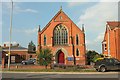
Gillingham Baptist Church
Also shown in Image, and at the junction of Le Neubourg Way (the B3081) and Newbury at the east edge of the town. The building dates from 1892. On the left is the church hall.
Image: © Derek Harper
Taken: 26 May 2016
0.09 miles
6
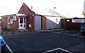
Royal British Legion Gillingham Club
Set back from School Lane, about 100 metres north of High Street. The Gillingham Royal British Legion blue plaque on the wall, dated 2014, records that the main part of the building was used as a ward for the Station Road Red Cross Hospital during the Great War 1914-1918. From 1921 it was a meeting place for the comrades of the Great War. It became the Sir Douglas Haig Club, later renamed The Royal British Legion Club.
Image: © Jaggery
Taken: 13 Dec 2014
0.10 miles
7
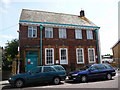
Gillingham: Royal Mail delivery office
The Local Delivery Office (LDO) for Gillingham, in Station Road, was once also the main post office (called Station Road, replacing an office called Gillingham on 1 August 1971) until 25 September 1995 when it moved into the High Street (see Image).
Image: © Chris Downer
Taken: 8 Aug 2009
0.10 miles
8
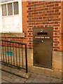
Gillingham: postbox № SP8 44, Station Road
This postbox is incorporated within the wall of the Image and receives its last daily collections – predictably the latest in the town – at 6pm on weekdays and at noon on Saturdays.
Image: © Chris Downer
Taken: 8 Aug 2009
0.10 miles
9

Gillingham Bowling Club
Formed in 1923, the club has a fine clubhouse (built in 2002) and a reputation for a top class rink.
Image: © Neil Owen
Taken: 6 Feb 2025
0.10 miles
10
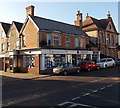
Hambledon Estate Agents office in Gillingham
On the corner of High Street and School Lane.
Image: © Jaggery
Taken: 13 Dec 2014
0.11 miles