IMAGES TAKEN NEAR TO
Thurstin Way, GILLINGHAM, SP8 4FN
Introduction
This page details the photographs taken nearby to Thurstin Way, SP8 4FN by members of the Geograph project.
The Geograph project started in 2005 with the aim of publishing, organising and preserving representative images for every square kilometre of Great Britain, Ireland and the Isle of Man.

There are currently over 7.5m images from over14,400 individuals and you can help contribute to the project by visiting https://www.geograph.org.uk
Image Map
Images are licensed for reuse under creativecommons.org/licenses/by-sa/2.0
Notes
- Clicking on the map will re-center to the selected point.
- The higher the marker number, the further away the image location is from the centre of the postcode.
Image Listing (13 Images Found)
Images are licensed for reuse under creativecommons.org/licenses/by-sa/2.0
Image
Details
Distance
1
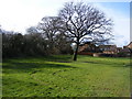
Ancient Trees!
These trees are on a small green open space along Gyllas Way at Peacemarsh, Gillingham. To the left are the remains of an Ancient Woodland hedgerow.
Image: © Clive Warneford
Taken: 6 Feb 2008
0.05 miles
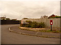
2
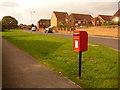
Gillingham: postbox № SP8 20, Gyllas Way
This postbox stands on the corner of Highgrove, down which it faces, and is emptied finally at 5:45pm on weekdays and at 11:45am on Saturdays.
Image: © Chris Downer
Taken: 18 Oct 2009
0.05 miles
3
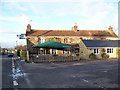
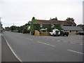
The Dolphin near Gillingham
Situated on the B3092 between Mere and Gillingham.
Image: © Maigheach-gheal
Taken: 23 Nov 2008
0.18 miles
4

Sign for the Dolphin
Ancient seamen looked upon the dolphin as a creature who would help them in storms by twining itself around the anchor cable, thus preventing the anchor of dragging. The name has been used by ships of the Royal Navy from 1646 until the present day. Dolphins also figures in the coats of arms of the Fishmongers Company and the Company of Watermen and Lightermen. This is the sign for Image
Image: © Maigheach-gheal
Taken: 23 Nov 2008
0.18 miles
5
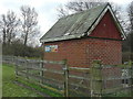
The Colesbrook monitoring station on the river Stour
One of a number of automated river flow and height monitoring stations that are found throughout the UK on most rivers. See here for today's reading at the Colesbrook station: http://www.environment-agency.gov.uk/homeandleisure/floods/riverlevels/120714.aspx?stationId=3308
Image: © David Redwood
Taken: 13 Dec 2012
0.20 miles
6
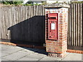
Gillingham: a postbox catches the sunlight
A much more useful view of Image, in terms of making out the George VI cipher and the brickwork of the pillar, which looks a little damaged in one corner.
Image: © Chris Downer
Taken: 14 Oct 2012
0.22 miles
7
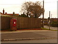
Gillingham: postbox № SP8 59, Fairey Crescent
This George VI-reign postbox is set into a brick pillar on the corner of Fairey Crescent and the B3092 which, seemingly, does not have a road name. It is emptied finally at 5:45pm on weekdays and at 11:45am on Saturdays.
Image: © Chris Downer
Taken: 18 Oct 2009
0.23 miles
8
Gillingham: postbox № SP8 123, Wessex Way
This postbox is emptied finally at 5:45pm on weekdays and at 11:45am on Saturdays. Further to the left are two drop boxes (see below).
Image: © Chris Downer
Taken: 18 Oct 2009
0.23 miles
9
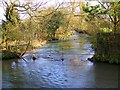
Shreen Water
Shreen Water is a tributary of the River Stour.
Image: © Maigheach-gheal
Taken: 1 Feb 2009
0.23 miles
10
The Dolphin
A view looking north across the B3092 towards the Dolphin public house.
Image: © Phil Williams
Taken: 13 Aug 2006
0.23 miles