IMAGES TAKEN NEAR TO
Fryern Court Road, FORDINGBRIDGE, SP6 1NA
Introduction
This page details the photographs taken nearby to Fryern Court Road, SP6 1NA by members of the Geograph project.
The Geograph project started in 2005 with the aim of publishing, organising and preserving representative images for every square kilometre of Great Britain, Ireland and the Isle of Man.

There are currently over 7.5m images from over14,400 individuals and you can help contribute to the project by visiting https://www.geograph.org.uk
Image Map
Images are licensed for reuse under creativecommons.org/licenses/by-sa/2.0
Notes
- Clicking on the map will re-center to the selected point.
- The higher the marker number, the further away the image location is from the centre of the postcode.
Image Listing (24 Images Found)
Images are licensed for reuse under creativecommons.org/licenses/by-sa/2.0
Image
Details
Distance
1
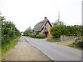
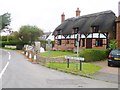
Upper Burgate, Lilac Cottage
On Fryern Court Road, thatched cottage with C16 origins. Listed by English Heritage: http://www.imagesofengland.org.uk/Details/Default.aspx?id=143958&mode=adv
Image: © Mike Faherty
Taken: 15 Oct 2014
0.02 miles
2
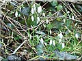
Snowdrops, Burgate
In sheltered places in south-west England the snowdrop beings to flower at Christmas, and in other parts it is welcomed as one of the first signs of spring, flowering from January to March.
The drooping, bell-shaped flowers have six segments - three white ones outside the flower and three tipped with a bright spot inside it.
It is doubtful whether the snowdrop (Galanthus nivalis) is a native of Britain. It was probably introduced in medieval times from central Europe and it is rare in Ireland.
Image: © Maigheach-gheal
Taken: 29 Jan 2010
0.02 miles
3
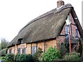
Lilac Cottage, Upper Burgate
Half timbered 16th century cottage.
Image: © Maigheach-gheal
Taken: 29 Jan 2010
0.04 miles
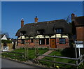
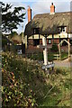
5
Upper Burgate, Bryants Cottage
C17 thatched cottage at the junction of A338 and Fryerns Court Road. Listed by English Heritage: http://www.imagesofengland.org.uk/Details/Default.aspx?id=143960&mode=adv
Image: © Mike Faherty
Taken: 15 Oct 2014
0.05 miles
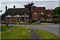
6
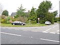
Burgate Cross
Perhaps a visual pun on "cross" as symbol or crossroads - at the junction of A338 and Fryern Court Road.
Image: © Mike Faherty
Taken: 15 Oct 2014
0.05 miles
9
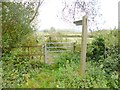
Upper Burgate, gate & signpost
Leading to the footpath from Upper Burgate to South Charford, an excellent project by Breamore Parish Council and partners to re-instate the trackbed of the former railway line.
Image: © Mike Faherty
Taken: 15 Oct 2014
0.07 miles
10
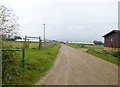
Upper Burgate, farm road
At the approach to Burgate Cross Farm, with poultry sheds in the distance.
Image: © Mike Faherty
Taken: 15 Oct 2014
0.10 miles