IMAGES TAKEN NEAR TO
East Woodyates, SALISBURY, SP5 5RA
Introduction
This page details the photographs taken nearby to SP5 5RA by members of the Geograph project.
The Geograph project started in 2005 with the aim of publishing, organising and preserving representative images for every square kilometre of Great Britain, Ireland and the Isle of Man.

There are currently over 7.5m images from over14,400 individuals and you can help contribute to the project by visiting https://www.geograph.org.uk
Image Map
Images are licensed for reuse under creativecommons.org/licenses/by-sa/2.0
Notes
- Clicking on the map will re-center to the selected point.
- The higher the marker number, the further away the image location is from the centre of the postcode.
Image Listing (6 Images Found)
Images are licensed for reuse under creativecommons.org/licenses/by-sa/2.0
Image
Details
Distance
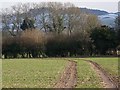
1
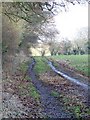
Footpath to Chettle Head Copse
The footpath goes around the edge of fields on a wide track until it reaches the copse.
Image: © Maigheach-gheal
Taken: 5 Mar 2009
0.10 miles
2
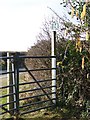
Footpath gate, Cobley
The footpath from Chettle Head Copse joins the minor road to Woodyates at this gate.
Image: © Maigheach-gheal
Taken: 5 Mar 2009
0.13 miles
3
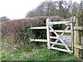
Footpath gate, Cobley Farm
The gate gives walkers access to the footpath from Cobley Farm to High Copse and West Woodyates Manor.
Image: © Maigheach-gheal
Taken: 24 Mar 2009
0.15 miles
4
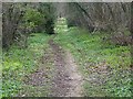
Footpath to Cobley Farm
The footpath takes walkers from Chettle Head Copse to Cobley Farm.
Image: © Maigheach-gheal
Taken: 24 Mar 2009
0.15 miles
5
Tram lines near Woodyates
The crop is growing well and the tractor lines are showing up well. Penbury Knoll in the distance has a light covering of snow.
Image: © Maigheach-gheal
Taken: 5 Mar 2009
0.19 miles
6
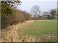
Hedge near Woodyates
It is difficult to date hedges unless there is documentary evidence as to their planting, but one theory is to count the species in a 30 metre stretch and each species counts as a century. Only count older plants and not saplings. The field is planted with a winter crop.
Image: © Maigheach-gheal
Taken: 26 Jan 2010
0.22 miles