IMAGES TAKEN NEAR TO
Ebbesbourne Wake, SALISBURY, SP5 5JB
Introduction
This page details the photographs taken nearby to SP5 5JB by members of the Geograph project.
The Geograph project started in 2005 with the aim of publishing, organising and preserving representative images for every square kilometre of Great Britain, Ireland and the Isle of Man.

There are currently over 7.5m images from over14,400 individuals and you can help contribute to the project by visiting https://www.geograph.org.uk
Image Map
Images are licensed for reuse under creativecommons.org/licenses/by-sa/2.0
Notes
- Clicking on the map will re-center to the selected point.
- The higher the marker number, the further away the image location is from the centre of the postcode.
Image Listing (4 Images Found)
Images are licensed for reuse under creativecommons.org/licenses/by-sa/2.0
Image
Details
Distance
1
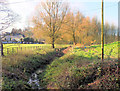
Upstream from May Bridge
Looking up the River Ebble, at this point it is approximately 2 miles from its source and a dry Autumn has reduced it to little more than a trickle.
The River Ebble is one of the five rivers of Salisbury. Rising at Alvediston, 12 miles to the west of the city, it then joins the River Avon at Bodenham. Managed by the Ebble Valley Conservation and Fishery Association (EVCAFA) to benefit the fish rather than the fisherman, the River Ebble is one of the Environment Agency's ‘Wild Fisheries Protection Zones’ (WFPZ). This means that the river cannot be stocked with any fish from its source to its confluence with the River Avon.
Image: © Jonathan Kington
Taken: 16 Dec 2011
0.06 miles
2
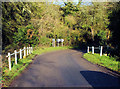
May Bridge
May Bridge crosses the upper end of the River Ebble at the eastern end of Ebbesbourne Wake, according to the yellow plaque on the left-hand buttress (Image) it was erected in 1936. There is a benchmark at the near end of the right-hand buttress, see Image
Image: © Jonathan Kington
Taken: 16 Dec 2011
0.20 miles
3
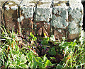
Benchmark on May Bridge
This, slightly damaged, cut mark is on the eastern buttress of Image, for more information visit http://www.bench-marks.org.uk/bm40554 .
Image: © Jonathan Kington
Taken: 16 Dec 2011
0.20 miles
4
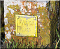
Information plaque on May Bridge
This small yellow plaque on the western buttress of Image gives the bridge number, R/12/65, and the year of building as 1936.
Image: © Jonathan Kington
Taken: 16 Dec 2011
0.20 miles