IMAGES TAKEN NEAR TO
The Warren, SALISBURY, SP5 1LU
Introduction
This page details the photographs taken nearby to The Warren, SP5 1LU by members of the Geograph project.
The Geograph project started in 2005 with the aim of publishing, organising and preserving representative images for every square kilometre of Great Britain, Ireland and the Isle of Man.

There are currently over 7.5m images from over14,400 individuals and you can help contribute to the project by visiting https://www.geograph.org.uk
Image Map
Images are licensed for reuse under creativecommons.org/licenses/by-sa/2.0
Notes
- Clicking on the map will re-center to the selected point.
- The higher the marker number, the further away the image location is from the centre of the postcode.
Image Listing (11 Images Found)
Images are licensed for reuse under creativecommons.org/licenses/by-sa/2.0
Image
Details
Distance
1
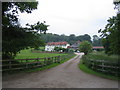
Warren Farm, The Warren, Buckholt
This is a very large farmhouse on the west side of The Warren, the unclassified road that runs north from a C road north of West Tytherley to the A30 road.
Image: © Andy Gryce
Taken: 10 Jun 2007
0.03 miles
2
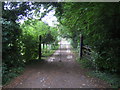
Gates, Warren Farm Cottages, Buckholt
These are the gates to one of the two cottages of Warren Farm Cottages on the west side of The Warren, the unclassified road that runs from a C road north of West Tytherley to the A30 road. In the garden, a big turkey, now out of sight, was on guard.
Image: © Andy Gryce
Taken: 10 Jun 2007
0.13 miles
4
Track near Khyber Pass, Buckholt
This is a section of a track, which is not a public right of way, that runs in a roughly north-east direction from Little Buckholt Farm in the south to London Lodge on the A30 about 3km away. This view, looking north-east is about 1/2km from Little Buckholt Farm. From here the track rises gently to a dip in Broughton Down at a height of about 125m, known locally as Khyber Pass, and then descends quite steeply on the other side, hence the name.
This track was the subject of an unsuccessful application by a recreational off-road motoring organisation in May 1996 to have it declared a Byway Open to All Traffic. The record of Hampshire County Council's Rights of Way Panel http://www.hants.gov.uk/scrmxn/c19600.html is interesting reading in the detailed history of the track that is uncovered.
Between Little Buckholt Farm and Khyber Pass the track also marks the western boundary of Buckholt civil parish, which is the smallest parish by population in the borough of Test Valley, with just 10 people.
Image: © Andy Gryce
Taken: 10 Jun 2007
0.18 miles
5
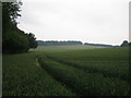
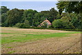
Field near Warren Farm, Buckholt
This view looking north-east from The Warren, the unclassified road that runs north from a C road north of West Tytherley to the A30 road, is of a very large wheat field rising up to the western end of Broughton Down. The highest point, at the gap in the trees, is 153m.
Image: © Andy Gryce
Taken: 10 Jun 2007
0.18 miles
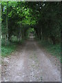
6
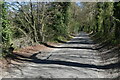
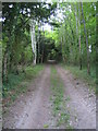
Tree-lined lane near Warren Farm Cottages
Image: © David Martin
Taken: 17 Apr 2021
0.19 miles
7
View across fields towards Kent's Wood
Image: © David Martin
Taken: 29 Sep 2013
0.20 miles
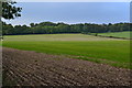
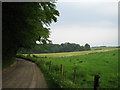
8
Lane and field edge north of Warren Farm
Image: © David Martin
Taken: 17 Apr 2021
0.20 miles
9
Track near Khyber Pass, Buckholt 2
This is a section of a track, which is not a public right of way, that runs in a roughly south-west direction from Norman Court Manor (on site of London Cottage) on the A30 in the north to Little Buckholt Farm about 3km away. This view, looking south-west is about 1/2km north of Little Buckholt Farm. For more information see Image
Image: © Andy Gryce
Taken: 10 Jun 2007
0.21 miles
10
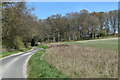
The Warren near Warren Court Farm, Buckholt
This view looking south-west-south from just south of near Warren Court Farm Cottages is of The Warren, the unclassified road that runs north from a C road north of West Tytherley to the A30 road. In the centre of the photo are the woods that surround Warren Farm, see Image, and the line of trees in the far distance on the horizon mark the county boundary between Hampshire and Wiltshire.
Image: © Andy Gryce
Taken: 10 Jun 2007
0.22 miles