IMAGES TAKEN NEAR TO
The Green, SALISBURY, SP4 6PB
Introduction
This page details the photographs taken nearby to The Green, SP4 6PB by members of the Geograph project.
The Geograph project started in 2005 with the aim of publishing, organising and preserving representative images for every square kilometre of Great Britain, Ireland and the Isle of Man.

There are currently over 7.5m images from over14,400 individuals and you can help contribute to the project by visiting https://www.geograph.org.uk
Image Map
Images are licensed for reuse under creativecommons.org/licenses/by-sa/2.0
Notes
- Clicking on the map will re-center to the selected point.
- The higher the marker number, the further away the image location is from the centre of the postcode.
Image Listing (53 Images Found)
Images are licensed for reuse under creativecommons.org/licenses/by-sa/2.0
Image
Details
Distance
1
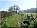
Footpath to Great Durnford
The footpath takes walkers from Upper Woodford past Durnford Mill to Great Durnford.
Image: © Maigheach-gheal
Taken: 9 Apr 2008
0.06 miles
2
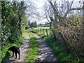
Footpath, Upper Woodford
The footpath takes walkers from Upper Woodford to Durnford, on its way it passes many pony paddocks.
Image: © Maigheach-gheal
Taken: 9 Apr 2008
0.10 miles
3
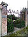
Gates, Upper Woodford
These impressive gates are to Garden Cottage.
Image: © Maigheach-gheal
Taken: 1 Jan 2011
0.11 miles
4
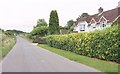
Road leaving Upper Woodford
Past what may look like the last house in the village, although there is another down a track just beyond the driveway, a track which carries footpath WFOR 11.
Image: © Derek Harper
Taken: 16 Jul 2016
0.12 miles
6
NCN Route 45, Upper Woodford
National Route 45 of the National Cycle Network when finished, will connect Salisbury in Wiltshire with Chester in Cheshire, via Swindon, Cirencester, Gloucester, Worcester and Whitchurch. Here the post tells cyclists that it is 6 miles to Salisbury and 4 miles to Amesbury.
Image: © Maigheach-gheal
Taken: 1 Jan 2011
0.14 miles
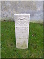
7
NCN milepost, Upper Woodford
On the verge by Garden Cottage is a National Cycle Network milepost. For a closer view of the post Image
Image: © Maigheach-gheal
Taken: 1 Jan 2011
0.14 miles
8
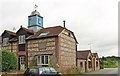
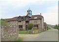
Kings Stables, Upper Woodford
The flamboyant decoration on the clock tower has suffered since Image was taken. The conversion is part of the buildings at Upper Woodford Farm. NCN45 uses the road past.
Image: © Derek Harper
Taken: 17 Jul 2016
0.14 miles
9
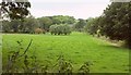
Meadows near Woodford Bridge
The cottage glimpsed is across the Avon in Upper Woodford.
Image: © Derek Harper
Taken: 17 Jul 2016
0.14 miles
10
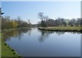
River Avon, Upper Woodford
Taken from the car park of the pub. Looking upstream.
Image: © Maigheach-gheal
Taken: 9 Apr 2008
0.14 miles