IMAGES TAKEN NEAR TO
Winterbourne Gunner, SALISBURY, SP4 6JQ
Introduction
This page details the photographs taken nearby to SP4 6JQ by members of the Geograph project.
The Geograph project started in 2005 with the aim of publishing, organising and preserving representative images for every square kilometre of Great Britain, Ireland and the Isle of Man.

There are currently over 7.5m images from over14,400 individuals and you can help contribute to the project by visiting https://www.geograph.org.uk
Image Map
Images are licensed for reuse under creativecommons.org/licenses/by-sa/2.0
Notes
- Clicking on the map will re-center to the selected point.
- The higher the marker number, the further away the image location is from the centre of the postcode.
Image Listing (35 Images Found)
Images are licensed for reuse under creativecommons.org/licenses/by-sa/2.0
Image
Details
Distance
1
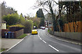
A338 towards Salisbury
Descending to cross the Bourne.
Image: © Robin Webster
Taken: 1 Apr 2018
0.00 miles
2
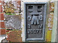
Ordnance Survey Flush Bracket S8371
This can be found on the wall of a building of a private dwelling in Winterbourne Gunner.
For more detail see : http://www.bench-marks.org.uk/bm19260
Image: © Peter Wood
Taken: 12 Feb 2017
0.07 miles
3
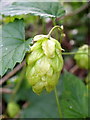
Hops (Humulus lupulus), West Gomeldon
The hop was growing in Britain long before it was taken into cultivation in the early 16th century for flavouring beer. Originally, it was probably a native of wet woods in the south of England.
In spring the plant sends up several thin, twining stems which grow rapidly and have a rough surface, as do the leaves. There are male and female plants, and it is the female flowers which develop into the green-yellow cones covered in resinous glands which are used for brewing.
For a wider view http://www.geograph.org.uk/photo/2061891
Image: © Maigheach-gheal
Taken: 4 Sep 2010
0.07 miles
4
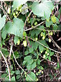
Hops (Humulus lupulus), West Gomeldon
The hop was growing in Britain long before it was taken into cultivation in the early 16th century for flavouring beer. Originally, it was probably a native of wet woods in the south of England.
In spring the plant sends up several thin, twining stems which grow rapidly and have a rough surface, as do the leaves. There are male and female plants, and it is the female flowers which develop into the green-yellow cones covered in resinous glands which are used for brewing.
Image: © Maigheach-gheal
Taken: 4 Sep 2010
0.07 miles
5
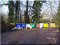
Recycling Area at Winterbourne Gunner
Image: © Maigheach-gheal
Taken: 14 Jan 2007
0.10 miles
6
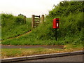
Winterbourne Gunner: postbox № SP4 160, Down Barn Road
This postbox stands by the roundabout where the A338 turns right from Winterbourne Gunner heading north towards Tidworth. It is emptied finally at 4:15pm on weekdays and at 9:45am on Saturdays.
Image: © Chris Downer
Taken: 1 Jun 2010
0.11 miles
7
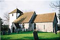
Winterbourne Gunner: parish church of St. Mary
Image: © Chris Downer
Taken: 14 Feb 1994
0.12 miles
8
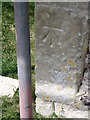
Bench Mark, St Mary's Church
The bench mark is on the south side of the church tower. For a view of the church http://www.geograph.org.uk/photo/2061750 and for more information on the cut mark http://www.bench-marks.org.uk/bm35500
A bench mark is an Ordnance Survey arrowhead sign found on walls, bridges, churches and specially erected triangulation pillars where the altitude above sea-level has been accurately measured by surveyors. The arrowhead points to a horizontal line above it which marks the exact altitude.
With rivets and pivots there is no datum (horizontal line) cut, the pointed-to horizontal surface defining the datum height.
Image: © Maigheach-gheal
Taken: 4 Sep 2010
0.13 miles
9
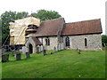
St Mary's Church, West Gomeldon
The church tower is of Norman design and is currently undergoing restoration. There is an Ordnance Survey bench mark on the south side of the tower.
Image: © Maigheach-gheal
Taken: 4 Sep 2010
0.13 miles
10
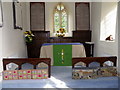
Interior, St Mary's Church
The Chancel is essentially 13th century but has been much restored. The Ten Commandments are on two painted boards and are hung each side of the east window - they are dated 1787.
Image: © Maigheach-gheal
Taken: 4 Sep 2010
0.13 miles